by Osprey Photo Workshops & Tours | Mar 19, 2022 | Bird photography, Nature Photography, Pennsylvania, Photo Workshops, Snow Geese, Swans, Wildlife Photography, Winter Photography

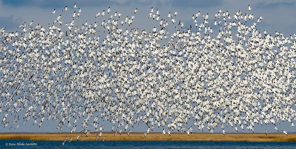
Snow geese lift off at Middle Creek Wildlife Management Area.
Middle Creek Wildlife Management Area, PA
At the beginning of March I spent a day and a half at Middle Creek Wildlife Management Area in Pennsylvania, approximately a 2.5 hour drive from my home near Baltimore. This was my first visit to the area. I could not resist packing up my camera gear and heading north when a friend from one of my photo workshops sent me a great image she had just taken at Middle Creek of a huge flock of snow geese taking off from a farm field.
Many years ago, 40,000 snow geese visited Chincoteague National Wildlife Refuge in November. I recall one afternoon during one of my photo workshops, while driving the Wildlife Loop we encountered thousands of snow geese in the impoundment and near the road. Periodically they would rise in unison from the ground sounding like a plane taking off. They would fly overhead, circle, and return to the same spot that they had left. Not only did they do this once, but repeated the behavior several times more. I have never forgotten that day. But in recent years the number of geese at Chincoteague has dropped dramatically. Many are now spending the winter at Bombay Hook and Prime Hook National Wildlife Refuges in Delaware with the geese feeding in the fields of the Delmarva Peninsula. It is reported, seasonal counts have exceeded 200,000.
At Middle Creek, I was a reminded of the past scenes at Chincoteague but with even more birds. During my visit on March 4th, there were 78,000 snow geese present with nearly 3,000 tundra swans. Periodically, the number of birds present in the winter were as high as 200,000.

Middle Creek Wildlife Management Area, PA
Middle Creek Wildlife Management Area is located on the boarder of Lebanon and Lancaster Counties in Pennsylvania, north of the town of Lancaster in the middle of Amish Country. Middle Creek is operated by the Pennsylvania Game Commission which is in charge of managing the wild bird and mammal populations at Middle Creek. This roughly 6000-acre wildlife management area is home to hundreds of species of birds and mammals. It is crucial for the hundreds of thousands of ducks, geese, and swans that visit during their spring and fall migration.
A number of accommodations are available approximately 20-25 minutes from Middle Creek at the towns of Ephrata and Lititz, PA.

Middle Creek Wildlife Management Area, PA
At Middle Creek there is a Visitors Center with interpretive displays, an auditorium, and an observation area with feeders and views of Middle Creek Lake. Also there are a number of walking trails, several picnic areas, a vehicle tour loop, and areas set aside for fishing and hunting. During the peak of the fall migration of waterfowl, to reduce disturbance of the birds, portions of the tour loop are closed to vehicles. However, from 1 March until 30 September, vehicles are permitted on the interior, northern part of the tour route.

The Lake
The impoundment (lake) where the snow geese, tundra swans, and other waterfowl congregate was created by the construction of a dam in the early 1970s. It is quite shallow, with an average depth of only three feet. Waterfowl attracted to the lake are those that prefer shallow water, compared to the diving ducks of the Chesapeake Bay. The deepest part of the lake is just above the dam where you might see herons, egrets and kingfishers.

Visitors Center Pond
The Visitors Center pond during the spring and fall migrations is an excellent spot to observe at a distance mallards, black ducks, northern shovelers, ring-necked ducks, wood ducks, hooded mergansers and others. The “tree-house” type structure located behind the pond is a bat condominium intended to serve as a maternal colony for up to 6,000 bats.

Kleinfeltersville Rd
Just past the road to the Visitor Center along Kleinfeltersville Rd on the right is an open area with a relatively clear view of the lake. When I was there, the cove was filled with snow geese in the morning and evening, with some at close range. They shared the area with Tundra Swans.At times more geese joined the group filling the sky with birds before landing. Eventually the main group of geese flushed and in mass, joined the other geese farther back in lake. To my surprise, the swans did not join them.. It may be a good spot to photograph flying geese at sunrise. However, most visitors gather at Willow Point for sunrise.


Willow Point Trail
The Willow Point Trail is very popular when the geese are present. It is an easy 10-minute paved walk that leads visitors to an observation point overlooking a large portion of the 360-acre lake. During spring migration, there are days when the waterfowl put on incredible flight displays, moving from one section of the lake to another. Occasionally, they would fly over the head of visitors before circling back to the lake. It was suggested that they took off in response to a bald eagle that left its perch on a dead tree across the lake and headed towards the flock.


Waterfowl Propagation Areas
From the Observation Point Parking Lot past Willow Point, it is possible to see activity within the waterfowl propagation area which is off limits to people. It is set aside to allow birds a place to nest, rest and feed unmolested year-round. In the spring and early summer you may see a variety of songbirds. Bird boxes attract tree swallows and bluebirds. In the fields you may see bobolinks.
On the southwestern portion of the lake there are three different types of nesting structures provided for waterfowl. Tire and tub structures provide a nesting areas for Canada geese. The straw tubes are provided for mallards and black ducks, while the box style structures are for wood ducks.


View from the interior loop road.
After observing the movement of geese from Willow Point and talking to other photographers, on my last afternoon in the area, I drove to the northern end of the interior tour loop where I thought the geese might be landing in a field close to the road. There were a number of cars parked at the side of the road which suggested I was right. I left may car at the end of the line and walked to where I had a clear view of the field and a number of geese on the ground. As I stood there photographing, other geese left the lake and joined the group. More and more geese arrived with some on the ground taking off and flying overhead to a field behind me. As sunset approached, the parade of geese leaving the lake continued with one “V” formation after another heading in my direction. I had hoped they would pass in front of where the sun was setting but most did not. However, I did capture a few images of lines of geese in front of the warm colors in the sky.


I plan to return in future years. Great wildlife photography opportunities.

by Osprey Photo Workshops & Tours | Mar 23, 2020 | Bird behavior, Bird photography, Blue Heron Reclamation Wetlands, Florida, Florida's Atlantic Coast, Nature Photography, Orlando Wetlands, Photo Workshops, Waste Water Reclamation, Wetlands, Wildlife, Wildlife Photography

Florida Sandhill Cranes at Orlando Wetlands
This is Part 1 of a report on the photography along Florida’s East Coast.
The last two weeks of February I flew to the East Coast of Florida to scout for a future photo workshop in March of 2021 or 2022. In the past, I have conducted several workshops in Florida but on the west coast and in the Florida Everglades. This time, I spent 12 days visiting 18 locations along the east coast from St. Augustine to Boca Raton. Sites included wildlife refuges, state parks, zoos, gardens, and wastewater reclamation wetlands. I spent the majority of time at locations where wildlife was abundant and accessible. At other sites, I limited my visit to just enough time to evaluate the area for inclusion in a workshop.
Because of my busy lecture schedule, my visit was limited to late February. Even though it is a month earlier than I plan to offer a workshop, wintering birds were present and nesting was beginning. Breeding birds were carrying sticks, constructing nests, fighting over territory, mating, and displaying. Many wading birds displayed nuptial plumes and the color changes that come with breeding. In a few nests, chicks were present. In late March and early April, heron rookeries are much more active with screeching, hungry chicks and parents busy feeding in order to care for their young.

Sandhill Crane Feeding in field. Orlando Wetlands.

Snowy egret photographed at Orlando Wetlands
Two sites covered by this newsletter are Orlando Wetlands and Blue Heron Water Reclamation Facility and Wetland Area. These are natural and man-made wetlands fed by reclaimed wastewater, creating an environment beneficial to wildlife. Both are within a short drive from Titusville. Florida has a number of these sites with some open to visitation by birders and photographers and others are closed to the public. Some encourage visitation with boardwalks for easy access and viewing of wildlife. Several have bird rookeries within their boundaries.

Limpkin with snail at Orlando Wetlands.
What is reclaimed waste water? It is raw wastewater that has passed through a sewage treatment plant to remove solids, toxic contaminants, and some nutrients. To kill pathogens, the waste is treated with chorine which dissipates before entering the wetlands. This “reclaimed,” non-potable water is sometimes discharged into waterways or dedicated to uses like watering lawns and other purposes, but not as drinking water. However, in some cases when discharged to waterways, the nutrient loading may be high enough to create choking algal blooms which can lower oxygen levels as the algae dies and is decomposed by bacteria. Low dissolved oxygen in waterways can produce “dead zones” where aquatic animals cannot live. On the other hand, when discharged into man-made or natural wetlands, the marsh plants take up the phosphorous and nitrogen and flourish, creating environments suitable for wildlife. For sites using wetland treatment of waste, they are proactively managed and the water tested. Their condition is monitored to benefit flora, fauna, and biochemical processes. In simple terms, at both Orlando and Blue Heron Wetlands, sections of natural or man-made marsh populated with native aquatic plants are impounded and surrounded by dikes with provisions for adjusting the water level as needed. Wetland plants support large populations of tiny aquatic organisms that form the basis of a food chain that supports higher organisms. This rich supply of food acts as a magnet attracting wildlife. In addition, wetlands provide shelter and nesting habitat for birds and serve as a nursery for aquatic organisms.
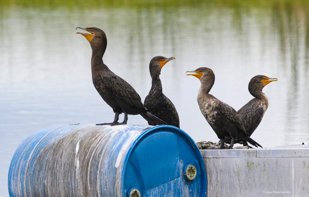
Double-crested Cormorant at Blue Heron Wetlands Facility
In the case of Orlando Wetlands, you can walk along the extensive series of dike roads. At certain times, you can take a tram tour of the facility. In the case of Blue Heron Water Reclamation Wetland Area, you must sign-in & out at their administrative office on site. When I was there, you could drive selected dike roads that provided great opportunities for photography with animals at close range and use to human presence. However, for all locations that I mention in this and the following newsletter, you must check current conditions and regulations.
A number of images in this newsletter are labeled with the location where they were taken. I first visited Orlando Wetlands about a half hour from Titusville. I walked along the dike roads expecting wildlife to be far away and intolerant of my presences. I was pleasantly surprised that many animals just ignored me and went about their normal activities. Alligators, limpkins, ibis, egrets, gallinules, and sandhill cranes were within easy camera range for photography. After conducting several December photo workshops at Bosque del Apache National Wildlife Refuge where thousands of sandhill cranes spend their time from mid-November to mid-February, I was surprised to see several cranes feeding in the first field I encountered. These Florida Sandhill Cranes are resident birds that nest in Florida and don’t migrate. They are omnivorous eating seeds, insects, frogs, mice and other organisms abundant in the marsh. Near Viera Wetlands, I actually saw a crane feeding in someone’s front lawn in the middle of a development. Later I discovered that they can be found on golf courses, parks, and in other public places.

Wood Stork sitting on branch at Orlando Wetland.
To visit Blue Heron Wetlands on weekends, you must make prior arrangements. In general many of the locations I visited were closed on certain days of the week. Those providing early entry for photographers who have purchased photo passes, such as St. Augustine’s Alligator Farm and Gator World’s rookery near Orlando, limit this privilege to certain days of the week or particular months, unfortunate for me February was not included. It is critical to check each location before visiting for rules, open dates, and conditions. For example, a favorite of many photographers, Green Cay Wetlands was closed to visitation due to renovations starting in November 2019. I had visited it several years ago and was impressed with its long boardwalk and large population of nesting birds.

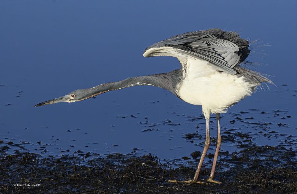
Great Blue Heron at Blue Heron Reclamation Wetlands exposing underside of wings.
In following newsletters, I will cover Merritt Island National Wildlife Refuge and Cape Canaveral National Seashore plus several other areas along Florida’s east coast. The pelican/spoonbill photo at the opening of this newsletter was shot on Merritt Island one morning during my recent visit.

Great Blue Heron resting at Blue Heron Reclamation Facility.

Great Blue Heron at Blue Heron Reclamation Facility.

Red-shouldered Hawk perched in tree on Blue Heron Reclamation Wetland.
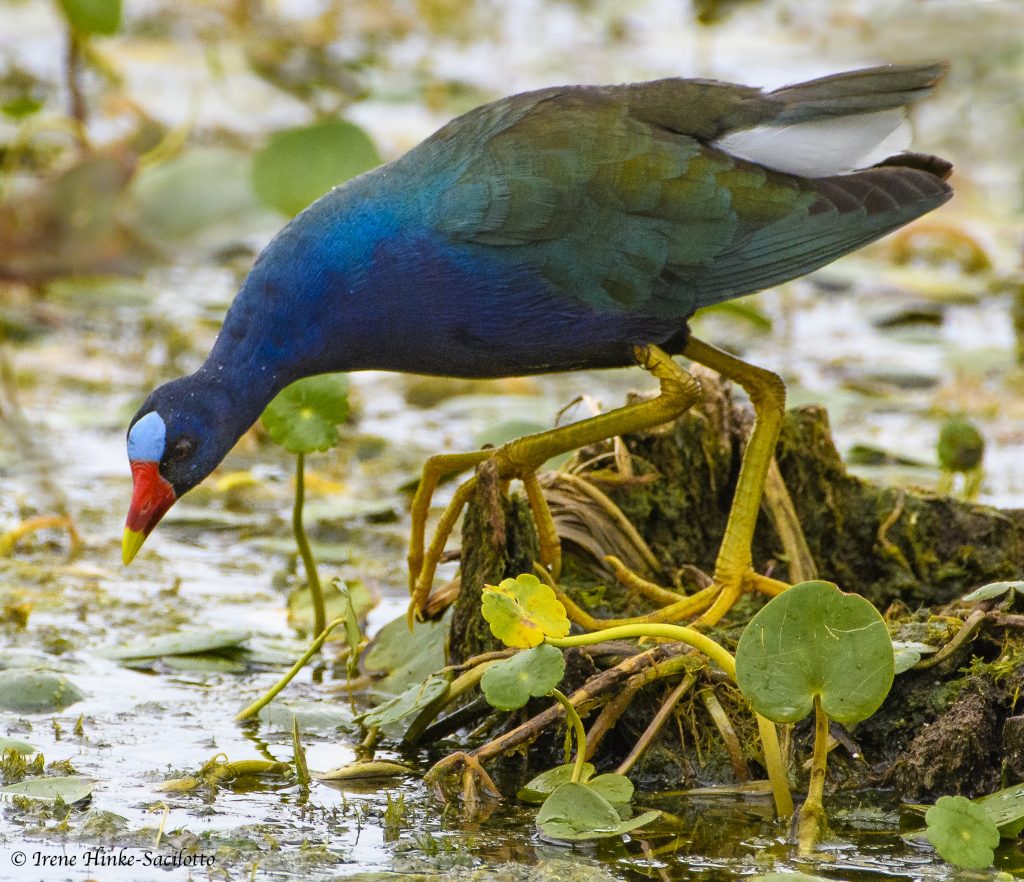
Purple Gallinule Feeding ay Blue Heron Reclamation Wetlands.
Tricolor Heron stretching on Merritt Island NWR Subject of next blog.

White Pelicans and Spoonbills at Merritt Island NWR.

by Osprey Photo Workshops & Tours | Apr 21, 2019 | Assateague, Chicoteague, Nature Photography, Photo classes, Photo instruction, Virginia, Wildlife Photography
Photo Opportunities
Chincoteague National Wildlife Refuge & Assateague Island National Seashore

Ospreys can dive to catch fish. Their feathers shed water easily and their talons specifically designed to be able to grab and fly with their catch.
Chincoteague National Wildlife Refuge and Assateague Island National Seashore
Location & Management:
Managed by the US Fish and Wildlife Service, Chincoteague National Wildlife Refuge covers 14,000 acres of beach, dune, marsh, shrub and forest habitats. The majority of the refuge is located on the Virginia end of the narrow, 37-mile-long barrier island of Assateague (Assateague Island National Seashore) just south of Ocean City Maryland. The refuge is managed to benefit wildlife and to protect critical habitat for both resident and migrating species. Birds found on the refuge include ducks, geese, heron, raptors, warblers, and shorebirds plus deer, raccoons, Delmarva Peninsula Fox Squirrels, muskrats, foxes, and otters.

In recent years, there has been a significant drop in the number of migrating snow geese visiting the refuge in the fall. Once reaching nearly 40,000, but today the numbers are much lower. Grabbed this shot several years ago as they landed on the beach. This fall, they were there again this year.
Large numbers of snow geese sometimes stop at Bombay Hook National Wildlife refuge, DE instead of proceeding south to Chincoteague in the fall. This flock circled several times before landing.
A number of impoundments have been created by refuge staff where water levels are managed to provide resting and feeding areas for waterfowl and other species. Some dikes bordering the enclosures are topped with roads adjacent to water-filled borrow ditches where birds congregate. This arrangement offers excellent opportunities to photograph wildlife from your car, steadying your camera on a bean bag or using another means of support. Because the animals are protected on the refuge and are used to seeing people and vehicles, they are less timid than elsewhere and more easily photographed.
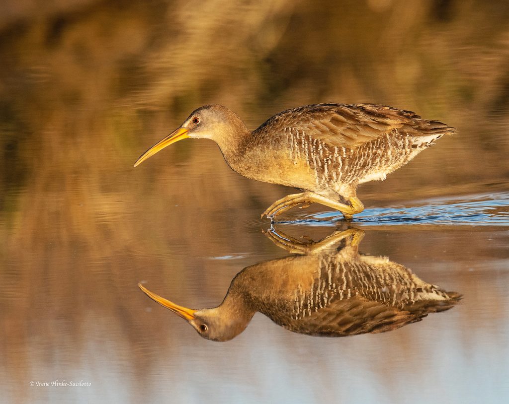
Clapper Rails are secretive birds found in the marshes. They feed at low tide on the exposed mud flats. Rails are often heard before seen.
Wild ponies are a favorite photo subject among visitors. Smaller than standard horses with heavy coats to protect them in this harsh environment. They appear perpetually pregnant with bloated bellies from their diet high in bulk and salt.

New born. Wild pony family.
Constant Change:
As with all barrier islands, the sand shifts with the season and strong storms. The ocean cuts through the dunes sometimes forming temporary inlets. Water-laden sand rolls over the land creating new marsh. With the landscape constantly changing, there are always new and exciting opportunities for photography. No matter when you visit, you will always find something to photograph. Even in the summer when the public beach is packed with people, you can still find photo subjects by venturing out in the early morning and late afternoon when there are fewer people to interfere with your activities.

Once endangered, Delmarva Peninsula Fox Squirrels were transplanted on Chincoteague and now they are often seen at the edge of the maritime forest.
Locating and approaching wildlife:
Spotting animals requires careful scanning of the environment for shapes, tones or colors out of place, and movement. By studying animals, whether photographing or not, you gain insight into their behavior and are better able to capture action shots. Creatures of habit, animals often visit the same locations repeatedly so check these spots on a regular basis. Know your equipment well and be prepared to photograph at any time. Have a suitable camera/lens combination ready with exposure settings pre-set for conditions you are likely to encounter. Once a potential subject is spotted, plan your approach. Consider the lighting, background, subject temperament, and the animals direction of movement. If it is following a predictable path, move slowly and indirectly to position yourself where it is heading. Be careful not to cause it to alter its behavior. Rapidly moving directly towards the animal will normally causes it to flee.

I watched the direction the fox was moving and carefully position my vehicle on the shoulder of the road at a distance in front of where I thought it was going. I made sure the warm afternoon light was illuminating its beautiful red coat

After hearing its distinctive call, I spotted this Belted Kingfisher on one of its favorite branches. As I positioned my camera, it plunged into the water and emerged with a small crab in its bill before returning to its perch. To capture various poses of the bird as the bird struggled to consume the crustacean, I held down the shutter release button and repeatedly fired a series of shots using a high number of frames/second.
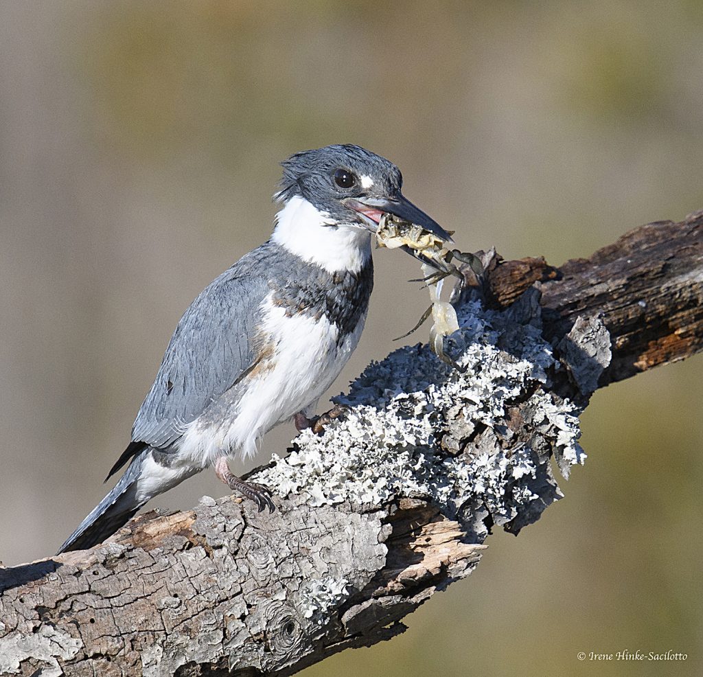
Shot from my car with my Nikon D850 camera and 600 mm lens resting on a bean bag. Settings: ISO 800, F10, and shutter speeds approximately 1/2000 second.
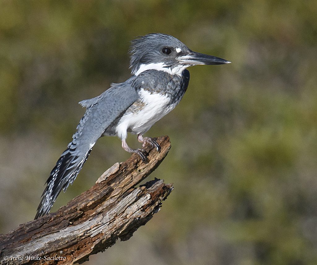
Belted Kingfisher stretched wing just before it dove after fish.
Suggested lenses and other gear:
- A wide-angle for beach scenes, flocks of birds, and sunrise/sunsets and perhaps a 80 to 200 mm zoom lens to isolate portions of the scene.
- A 300, 400 or 600 mm telephoto for small or timid subjects such as shorebirds. It is preferable to buy long lenses that have collars for mounting on a tripod. This makes it easier to handle the camera/lens combination and it allows for quick adjustment of orientation from horizontal to vertical or in-between.

To spot animals, I look for movement. This Cedar Waxwing was part of a flock attracted to the berries. Shot with my 600-mm lens.
- A 1.4 tele-converter to extend the effective focal length of your primary lens for photographing small subjects. Note: The tele-converter reduces the amount of light reaching the sensor, cutting shutter speeds in half. For best image quality, buy one matched to your prime lens.
- A 200-mm macro lens for close focusing and high magnification when photographing a shell, insect, or flower. Compared to shorter macro lenses, with the 200-mm lens, you can obtain the same magnification at a greater working distance from your subject–a benefit if photographing something timid such as a ghost crab.
- Other gear: An electronic shutter release to prevent camera shake when using long exposures or high magnification. A polarizing filter to remove unwanted reflections and shine on surfaces of vegetation intensifying colors. Depending on the angle of the sun, it can also make the sky appear bluer. You might want to include a neutral density filter that reduces the amount of light entering the lens in order to create special effects by using slow shutter speeds to suggest motion of moving objects – the surf, the wings of birds, etc.

The lighting and pose made this photo of a Great Blue Heron special. Shot in the early AM.
- A sturdy tripod, preferably without a center post for maximum stability when using long telephoto lenses. The tripod should be topped with a professional ball head that can easily support the weight of your camera/lens combination or with a Wimberley Head (gimbal) which is preferred by many photographers for manipulating large lenses and tracking animals and birds.
- If shooting on the beach, the wind off the ocean can be fierce and unpredictable, so never walk away from the tripod. Also, watch where you place your camera gear since an incoming wave can swamp your equipment or worse, wash it away. When around blowing sand or dust, shield your camera when changing lenses to avoid particles entering the throat of the camera and making their way to the sensor resulting in dark spots on your images.
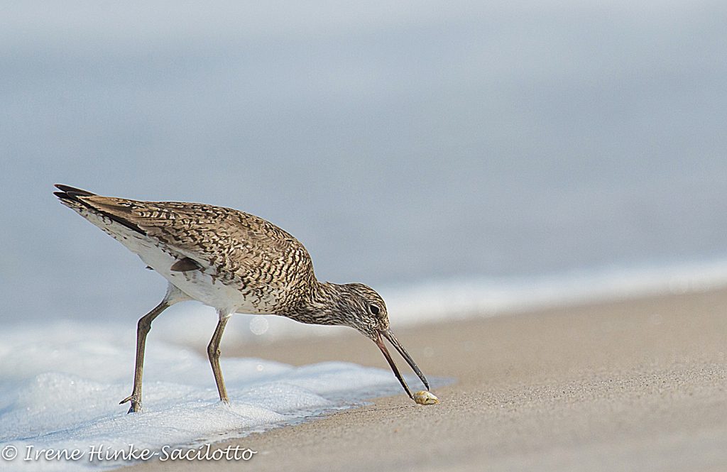
Willet picking up mole crab. Shorebird behavior is often predictable. They follow the edge of the surf, probing for organisms as waves retreat.
Useful tips:
- By having with you two cameras mounted with different lenses when in the field, you can avoid changing lenses in the open and can more quickly switch from one focal length to another.
- When on the beach, wipe or brush the sand off your tripod legs with a damp cloth to prevent particles and salt from entering the joints between tripod segments and making it difficult to adjust the tripod’s height. You can buy or create water-proof tube covers for the lower legs to minimize sand-related problems and to allow you to submerge the legs in the surf.
- If visiting in the spring, summer or early fall, bring insect repellant to guard against mosquitoes, biting flies, and ticks potentially carrying Lyme disease. Reads more on CDC’s website. https://www.cdc.gov/lyme/prev/on_people.html
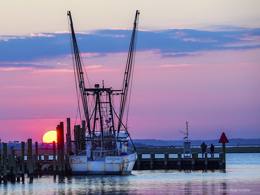
Adjacent to the refuge is the town of Chincoteague with a small boat harbor. Sometimes loons are found here. It is also a good place to photograph sunset.

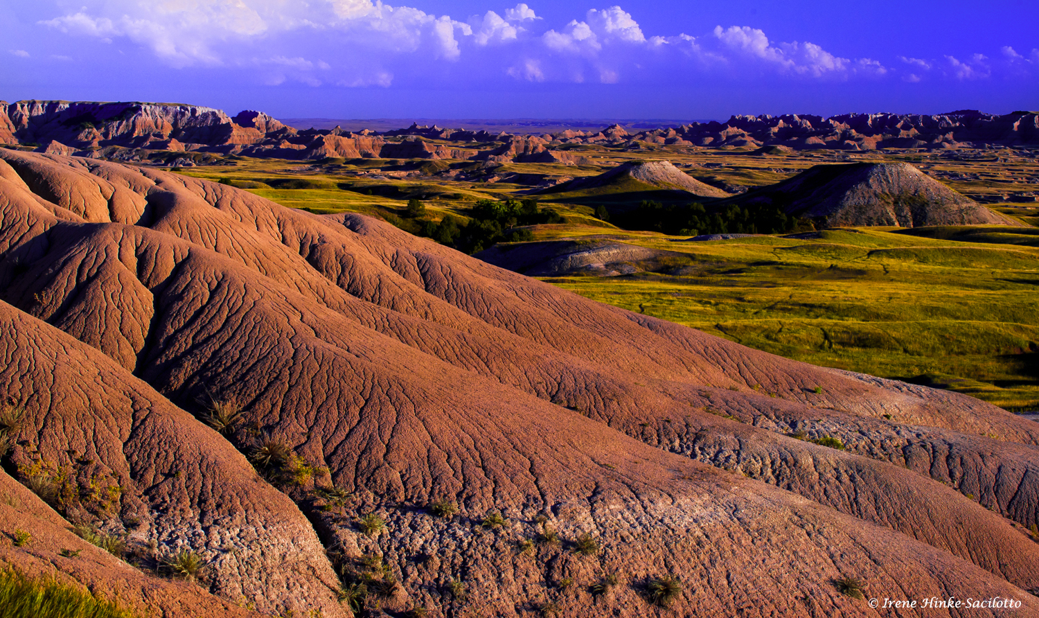
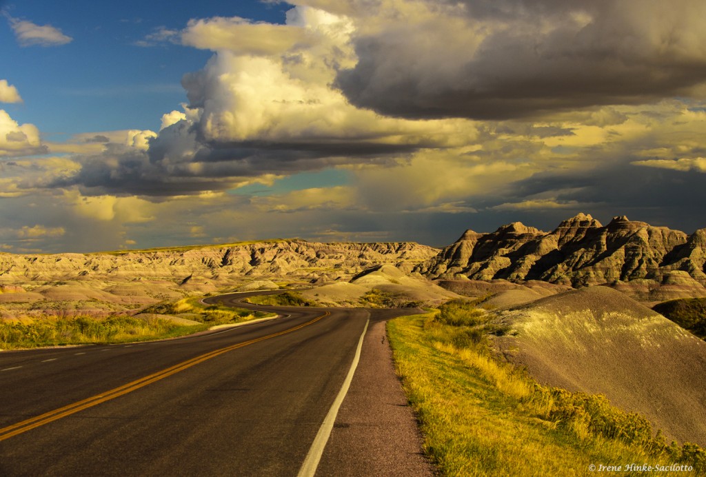
by Osprey Photo Workshops & Tours | Jul 17, 2017 | Badlands, Badlands National Park, Nature Photography, Photo Tour, Photo Workshops, Wildlife Photography
South Dakota Badlands Photos and Tips

The following blog introduces you to South Dakota Badlands Photos and Tips from my photo workshop this June.
In early June, I conducted a photo workshop in the Badlands of South Dakota with co-leader Sandy Zelasko. It is a great location for dramatic landscapes with striped limestone formations, sharp pinnacles, canyons, and sprawling prairie grasslands frequented by pronghorn and mule deer. In the past, I conducted photo tours in the Badlands and Blackhills in the fall. But this time, Sandy and I elected to hold the workshop in early June when newborn animals were plentiful along with vibrant spring colors. On most days, temperatures were comfortable in the morning but rose as the day progressed. Therefore, we were on location to shoot sunrise and photographed throughout the early morning. Then we took a mid-day break at our hotel in Wall to rest, review images, photograph around town, and grab an early dinner before returning into the field until sunset. From Wall, it was only a 25-minute drive to the park’s northeast entrance and 15 minutes to Pinnacles Overlook. The small town of Wall has several good restaurants, a grocery store where we bought snacks and food for breakfast, and a gas station plus a few convenience stores.

Note: Many of images you see in this newsletter were taken while scouting locations I the Badlands for the workshop. Sandy and I did photograph with clients at times but only if we were demonstrating techniques or in the event they did not desire our assistance.

Bighorn sheep are social animals with the females and lambs living separately from the males until breeding season. Rams, we encountered several times at the northeast end of the park near Big Badlands Overlook and the parking area at Notch, Door, and Windows trails. Remarkably, the length of the rams curled horns are managed as not to block their vision. While we photographed, they occasionally engaged in mock fighting which will become quite aggressive during rutting season in November and December as they compete for the attention of the females and run at each other heads down and horns clashing. The sound of the impact reverberates throughout the canyons. Even the youngsters engaged in shoving matches practicing for their roles later in life. The sheep’s ability to climb steep slopes even when small is amazing and is possible because of the rough pads on the bottom of their flexible two-toed hooves. It is wise to use long lenses (300 mm or greater) when photographing wildlife as not to alter their behavior. Wild animals are not predictable and these sheep can actually run at speeds of 30 mph over level ground.

These bighorn sheep once populated the park and other areas in the western U.S. in large numbers. But due to hunting and habitat loss their numbers dropped to near extinction at the beginning of the century. The bighorn seen the Badlands are Rocky Mountain sheep that were reintroduced into areas of the western U.S. In the Badlands, researchers monitor the health and distribution of the bighorn population by capturing lambs just after birth and attaching collars with tracking devices that will eventually fall off.

Young prairie dogs were one of the most entertaining but challenging subjects in the park to photograph. Our favorite family group was along Quinn Road where there was little traffic or disturbance. We photographed the youngsters at eye-level, lying on our bellies and using bean bags or low tripods for camera/lens support. This approach provided us with an intimate view of the animals and an out of focus background. Even though the background was blurred, we had to carefully examine the image in the viewfinder to be sure there are no strong forms or bright objects that could distract the viewer’s attention. The small prairie dogs were more animated than the adults particularly in the morning and during the cooler parts of the day. Therefore, we concentrated our effort on photographing them under those conditions, trying to capture their interactions — nuzzling, tail pulling, and playing.

Bison
Sage Creek Rim Road was the best location for bison. Late one afternoon as the sun was setting, I photographed a bison lit by the setting sun with the warm light illuminating the badlands in the background. One of my favorite photos from the trip.

Landscape Photo Opportunities
For dramatic landscape photos, we shot when the sun was low in the sky, warming and intensifying colors, and emphasizing the relief of the land. In the spring the weather is less stable than at other times of the year resulting in large cumulus clouds appearing in the afternoon along with dark, threatening storm clouds. Both add interest to images by replacing boring washed out or solid blue skies.
Some of the better views of the Badlands were at Yellow Mounds, Conata Basin, and Panorama Point Overlooks and the area from the Ben Reifel Visitor Center to Norbeck Pass. I particularly liked the views along the loop road from Pinnacles Overlook to Conata Road. There were convenient pull-offs along the way where we could stop and photograph multi-colored yellow mounds with contrasting banded formations in the background.
Some of the locations we used for sunrise and sunset photography were at or near Pinnacles Overlook, the red eroded rocks along Sage Creek Ridge Road, Big Badlands Overlook and at Windows, Door, Notch Trails.

Sheep Mountain Table
Sheep Mountain Table is in the south unit of Badlands NP. At the base of the plateau there are unusual rock nodule and toadstool-like formations. The road leading to the top is narrow and dirt can be treacherous after hard rains. We had a limited amount of time to explore the area due to an approaching storm with ominous dark clouds. However, it was the storm that added dimension to our images of the surrounding badland formations. Among the grasses on top of the table, we found the giant fuzzy puff balls containing seeds for the flower goat’s beard. One participant with a mirrorless camera took photos of the plant using a macro lens with a modeling light built-in. When comparing his images taken with this set-up to mine, his were far superior as the light penetrated to the center of the sphere. Great job Jim!

Lessons Learned
When the light on a scene was flat due to heavy clouds or deep shade, I still took photos using high ISOs to freeze action and hoped for the best. In many cases, the high ISOs resulted in unacceptable noise levels in my images (looks similar to film grain). I used Nik and Topaz software plug-ins with Adobe Photoshop and Lightroom to reduce the noise but I was not always satisfied with the results.
What was worse, the subjects appeared unrealistically flat and blended with the background. On the last day of the trip, I resorted to shooting video with my Nikon D500 camera, something I had only tried once before. My results from that day were not always perfect due to the wind, a focus issue, and my inexperience. However, because the animals were moving and interacting during the video. they no longer blended into the background and the images were much more engaging. Needless to say, I plan to learn more about filming videos and plan to experiment with the technique more in the future.

Images in this blog are from scouting trip and photo workshop in the South Dakota Badlands. Planning similar program in 2018.
To see details from June workshop go to https://www.ospreyphoto.com/event/badlands-national-park-spring-escape/

by Osprey Photo Workshops & Tours | Apr 7, 2017 | Badlands, Badlands National Park, Landscape Photography, Nature Photography, Photo Tours, Photo Workshops, Scenic Photography, South Dakota, Wildlife Photography
South Dakota Badlands
Badlands National Park
Article on Outdoor Photographer website by Irene Hinke-Sacilotto
Site of June Photo Workshop with Sandy Zelasko & Irene Hinke-Sacilotto
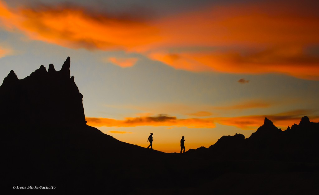
Hikers at Sunset
Badlands National Park is a terrific destination for landscape and wildlife photographers. It is the location of my June 2017 photo workshop, co-lead by Sandy Zelasko. The park is a convenient hour drive east from Rapid City on Interstate 90. North of the Pinnacles Entrance lies the town of Wall where you can find accommodations and other amenities. Near Cedar Pass, at the eastern end of the park, there are campgrounds, cabins, and a few other places to overnight.
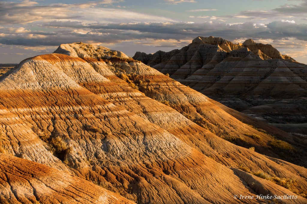
Banded sandstone formations
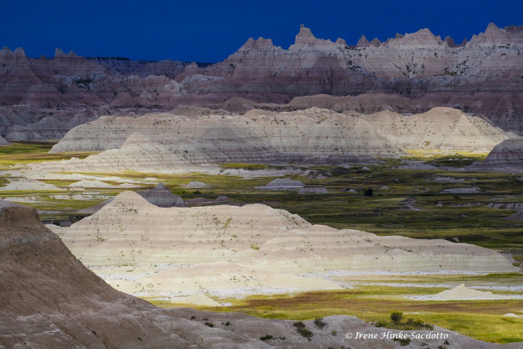
Badlands National Park Geology
Once the site of an ancient sea, the South Dakota Badlands have been transformed over thousands of years by wind and rain into the land you see today. Layers of sediment and ash eroded away leaving behind a rugged landscape with red and tan banded buttes, jagged escarpments with narrow gorges, and brightly colored yellow mounds. In the north unit of the park, there is a thirty-mile scenic loop road that meanders past unique geological formations. Along the way, there are convenient vehicle pull-offs, overlooks, and trails to explore.

Bighorn Sheep Ram.
Wildlife
At first glance, the land seems sterile, dry and wind-swept. Yet close examination reveals a variety of creatures including 39 mammal species. Bighorn sheep, pronghorn antelope, mule and white-tailed deer, bison, prairie dogs, coyotes, badger, jack-rabbits, cottontails, thirteen-lined ground squirrels, chipmunks, and fox squirrels make this park their home. If lucky, you might even spot the rare black-footed ferret, a species reintroduced into the area. Birds include hawks, eagles, magpies, meadowlarks, northern flickers, sharp-tailed grouse, turkey, and pheasant, just to name a few. Wildlife can be easily spotted from the road and are not as timid as elsewhere, due protection by the park service. Search picnic areas and campgrounds for photo opportunities including local free-loaders, such as magpies, squirrels and other foraging animals looking for food scraps and handouts.
Badlands Loop Road
Photo Opportunities
From the town of Wall, it is only a short drive to Pinnacles Overlook, a favorite of visitors for sunrise and sunset photography. Watch as the light slowly creeps across the landscape, illuminating and darkening sandstone formations in the distance. As you head east from Pinnacles Overlook towards Dillion Pass, the loop road travels through some of the most dramatic landscapes revealing yellow mounds in the foreground and jagged peaks behind. At Dillon Pass, you can take the Conata Road south through Buffalo Gap National Grasslands, a tiny remnant of the prairie that once covered huge expanses of land in North America and Mexico. If you climb east on Badlands Loop Road, you will reach Rainbow and other overlooks for great opportunities to photograph the “wall” that separates the lower and upper prairies. At every turn along the road, the topography changes, offering even more photo ops. Storm clouds can add drama to your photos filling up an empty sky and casting shadows across the landscape resulting in alternating patterns of light and dark.
Moving Shadows

Black-tailed prairie
dog
Black-tailed prairie dog towns can be found throughout the park and their occupants are among my favorite subjects to photograph. During our recent scouting trip, we determined one of the best colonies for photography was along Quinn Rd, a dirt road running north off of the loop road where traffic was sparse and there was little disturbance. Here the prairie dogs were more tolerant and allowed us to photograph them at eye level from outside of our vehicle. It was nearly impossible to predict which animal was going to pop out of its burrow and “bark” an alarm call. For the best chance of capturing one barking, carefully observe the colony looking for individuals that seemed more vigilant and concentrate your attention on them. Since the alarm call suggests the presence of danger, be on the lookout for coyote or other predators nearby.
There are a number of trails that you can explore throughout the park for unique photo opportunities. They vary from easy to strenuous in difficulty. Always carry plenty of water. Take time to stop in at the Ben Reifel Visitors Center to learn more about the park, check weather forecasts and ask rangers for up-to-date information on recent wildlife sightings.

Bighorn sheep along Sage Creek Rim Road
Don’t skip Sage Creek Rim Road, a well-maintained dirt road heading southwest and accessed just after the Pinnacles Entrance to the park. Beautiful vistas abound as you glance left (south) near the roads entrance. Rust-colored mounds with deeply furrowed patterns dominate the foreground. In the setting sun, they almost glow red with the reflected warm light. Check out the areas with prairie grasses and browse for bison, antelope and bighorn sheep. At dawn, you may be able to silhouette one of these animals on a ridge against the rising sun. Roberts Prairie Dog Town is a popular stop to see prairie dogs. Often an abundance of visitors fright them back into their burrows making this location not ideal for photography. I suggest looking farther down the road for better opportunities. On the fringes of the colonies, look for coyote and badger which sometimes hunt as a pair.
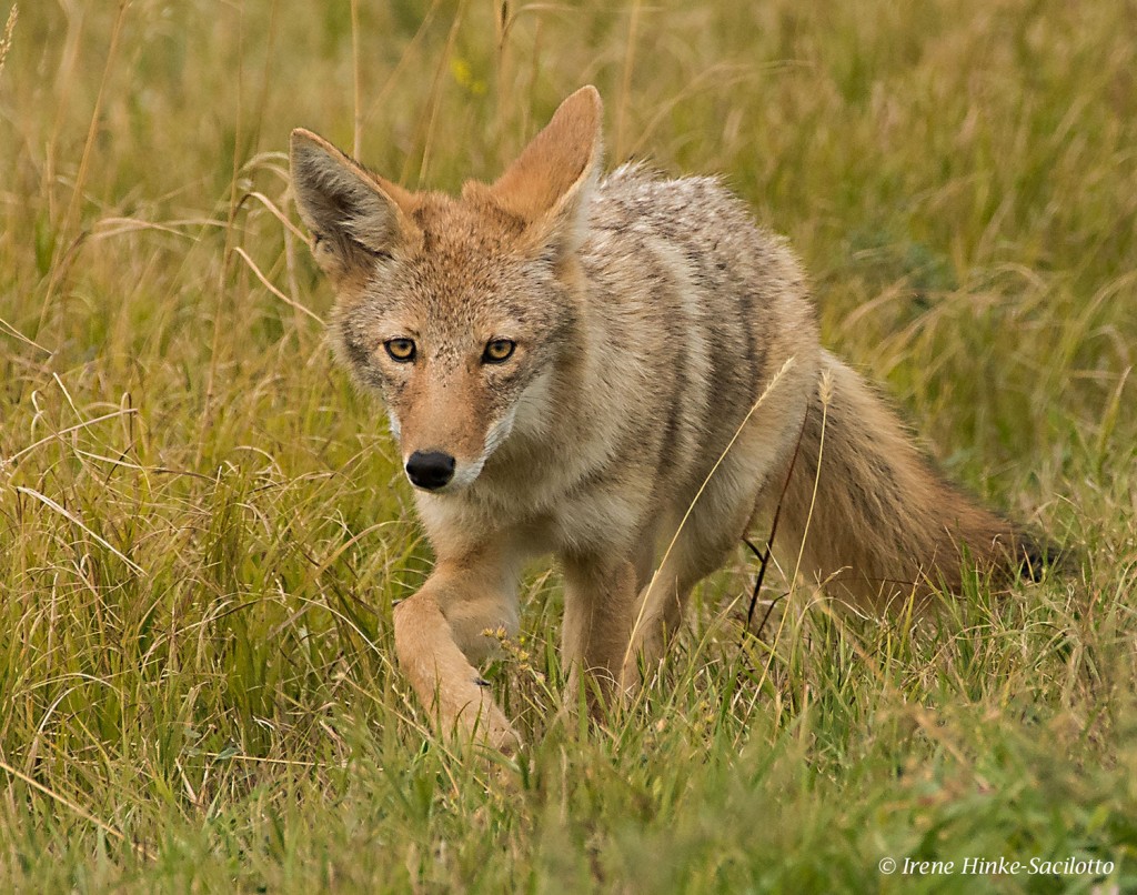
Stalking Coyote
Also check out woody draws where there is enough moisture to support shrubs, trees, and other plants. These sheltered areas are often havens for fox, deer, rabbits, squirrels and other wildlife. In autumn, these groves of trees add a splash of color to the dry landscape with leaves of yellow and gold. Be careful when stepping off trails. Burrows and prairie rattlesnakes might be concealed beneath the grass. Wear sturdy boots to negotiate uneven terrain and protection against cactus spines.

Fall color
Approaching & Photographing Wildlife
Make note of where you commonly see animals and check these locations on subsequent trips past the area. Photographing wildlife often relies on the animal accepting your presence as non-threatening. That means patience is important. Stalking tips: Move slowly, emulate their behavior, stop periodically, take an indirect route to close the distance, assume a low profile, and avoid direct eye contact. Minimize loud noises, perfumes, or anything not typically found in their environment. Camouflage clothing can help you merge with the surroundings and avoid curious human on-lookers from approaching you.

Pronghorn at rest
When photographing, make sure you do not disturb the animal’s behavior. If it reacts, stop and wait before resuming your approach. Curiosity may even bring them closer to you. Never block an animal’s means of escape or stand in their path. Just because they are in a national park, wildlife is unpredictable and can be dangerous particularly if traveling with young. Obey park regulations. Don’t feed wildlife.

Bison Scratching
Suggested equipment:
- DLSR camera with good response in low light at high ISOs
- Lenses from wide angle to telephoto. (My 200 – 500 mm Nikon zoom lens was handy when I needed to react quickly to wildlife subjects.)
- A matching tele-converter
- A macro lens if you enjoy close-up photography
- Large bean bag to support your camera when photographing from a vehicle
- Sturdy tripod mounted with a ball or gimbal head.
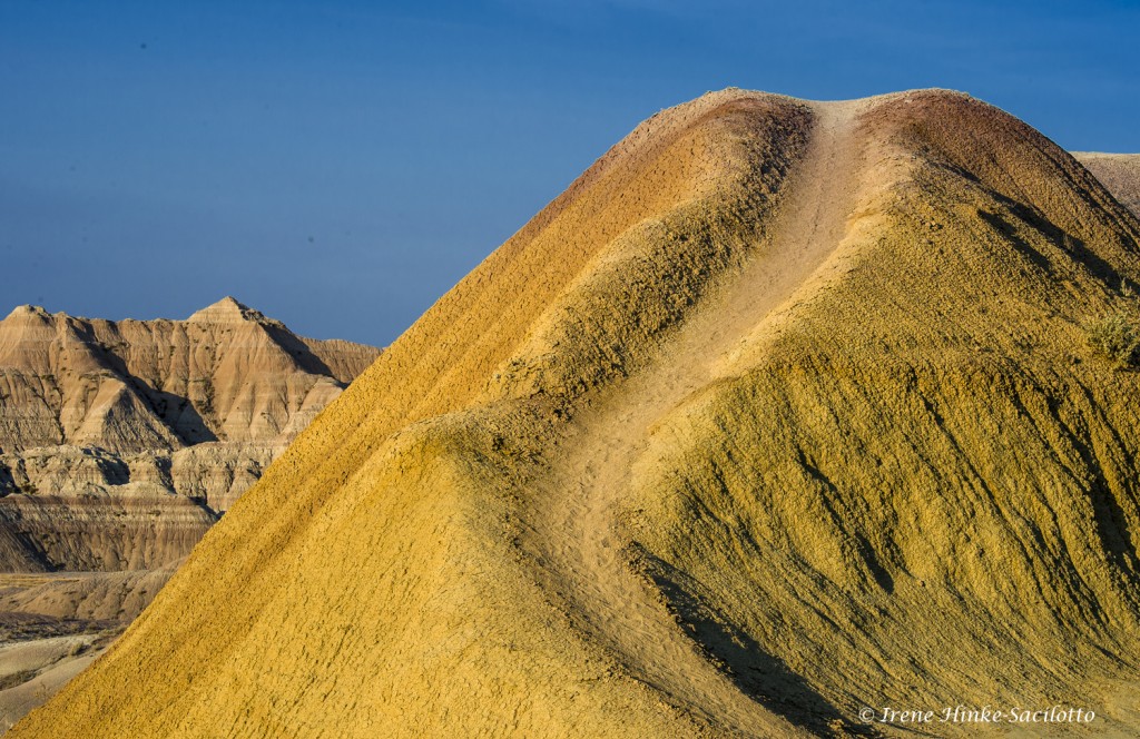
Yellow Mounds Near Dillon Pass
Check out the upcoming Photo Workshop 4-9 June, 2017 with Irene Hinke-Sacilotto & Sandy Zelasko. www.ospreyphoto.com

Meadow Lark Singing

Eroded Landscape