by Osprey Photo Workshops & Tours | Aug 31, 2024 | Newfoundland, Photo Tour, Photo Tours, Scenic Photography, Uncategorized
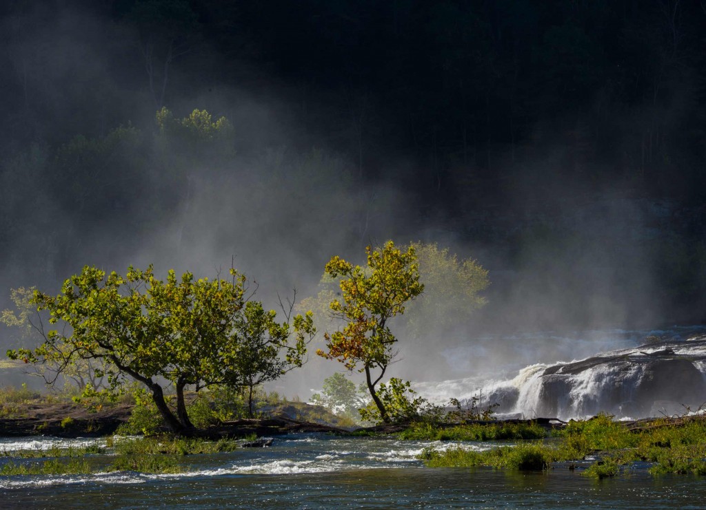
Newfoundland is one of my favorite places to visit because it is great for photography of wildlife, scenic coastlines, and quaint harbors. Years ago I visited Newfoundland with a friend and the next year conducted a small tour there that included Labrador. In 2023 another friend and I visited the Canadian island again. What I experienced on that trip convinced me to offer tours there again. In June & July 2024, I created and conducted two tours concentrating on the Avalon and. Bonavist Penninsulas. Below you can find the locations visited including St John’s, Quidi Vidi, Witless Bay, Cape St. Mary’s Ecological Reserve, St. Brides, Bonavista, and the town of Trinity. Images in this blog include photos from these locations.
During the week between the two 2024 tours, I visited areas I had not seen before–Change Island and Fogo Island, both north of the Bonavista Peninsula. In this blog, I included a few images from these islands. Also included are 3 icebergs photos taken in 2023 near Main Brook. Typically each year icebergs originate in Greenland and drift south in May & early June reaching Trinity Bay. But in 2023, the bergs never reached locations farther south than St. Anthony’s.
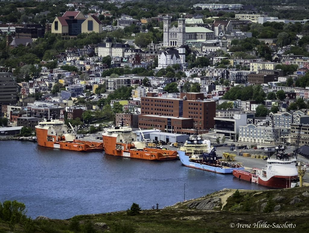
St. John’s Harbor

Fort Amherst guarding St. John’s Harbor & the Narrows

View from Signal Hill
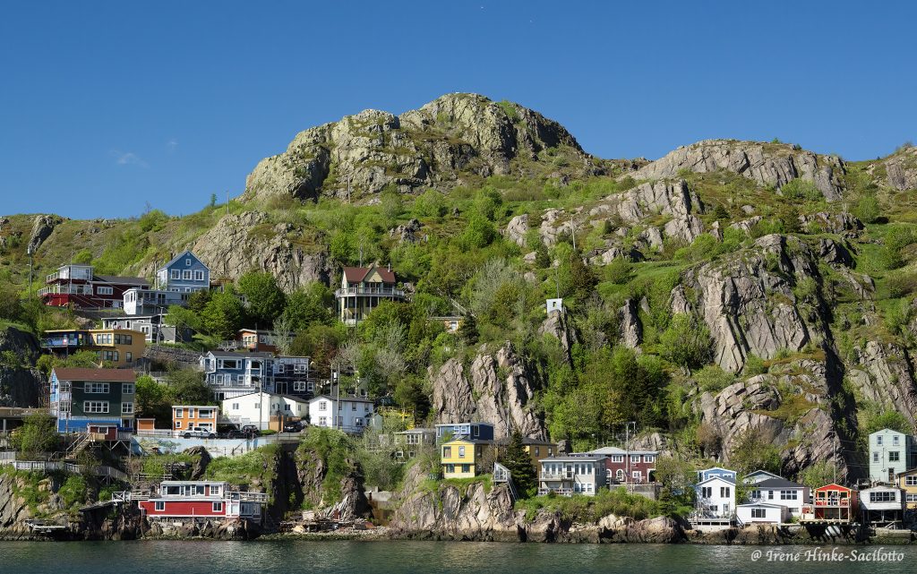
Battery Hill, St. John’s

Quidi Vidi Harbor

Cape Spear lighthouse from cliff

Cape Spear fog rising.

Cape Spear Fence & Older Lighthouse

Petty Harbor

Petty Harbor

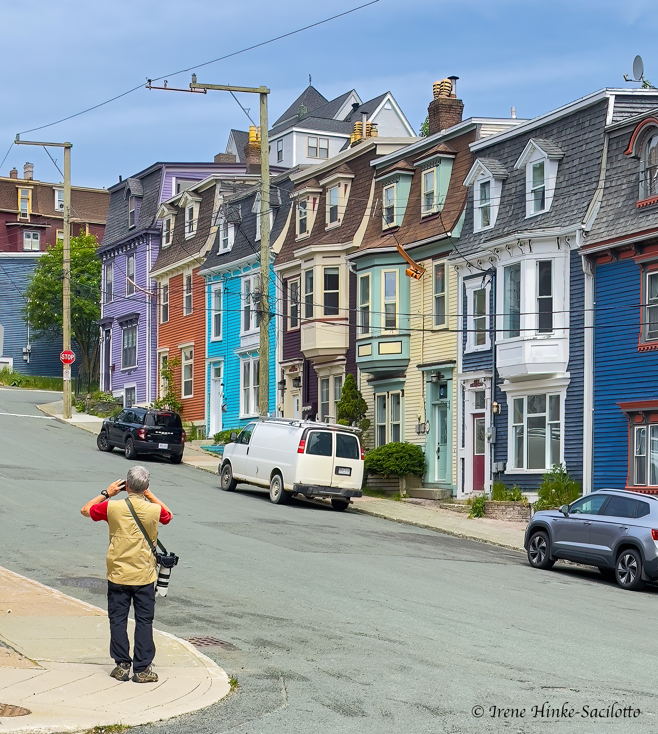
Jelly Bean House in St. John’s

Photographer & Jelly Bean Houses in St. John’s

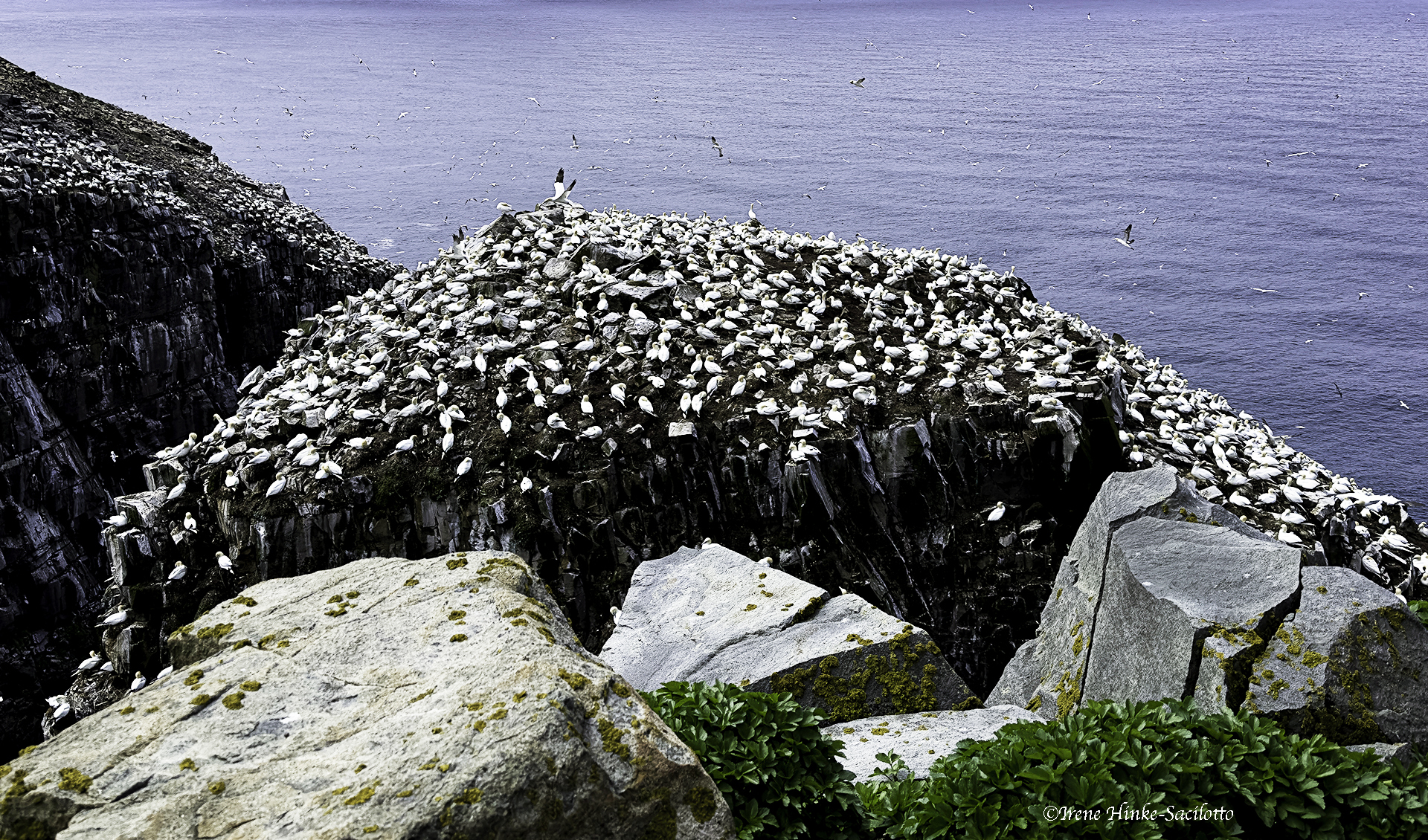
Gannet Rock at St. Mary’s Ecological Reserve

St Mary’s Cliffs


Trinity – Lupine along road

St. Brides Sunset

St. John the Baptist Church in Trinity

Dungeon Provincial Park, Collapsed Arches

Dungeon Provincial Park

Bonavista Lighthouse

Bonavista Lighthouse photographed from the water.

Change & Fogo Island Ferry in the pouring rain

Main Tickle on Change Island

Shacks on Change Island with reflections

Change Island Harbor

Boat & Shed, Change Island


Iceberg near Main Brook (from 2023 trip)

Iceberg near Main Brook (2023 trip)

Iceberg Near Main Brook, (2023 trip)

by Osprey Photo Workshops & Tours | Jul 17, 2017 | Badlands, Badlands National Park, Nature Photography, Photo Tour, Photo Workshops, Wildlife Photography
South Dakota Badlands Photos and Tips

The following blog introduces you to South Dakota Badlands Photos and Tips from my photo workshop this June.
In early June, I conducted a photo workshop in the Badlands of South Dakota with co-leader Sandy Zelasko. It is a great location for dramatic landscapes with striped limestone formations, sharp pinnacles, canyons, and sprawling prairie grasslands frequented by pronghorn and mule deer. In the past, I conducted photo tours in the Badlands and Blackhills in the fall. But this time, Sandy and I elected to hold the workshop in early June when newborn animals were plentiful along with vibrant spring colors. On most days, temperatures were comfortable in the morning but rose as the day progressed. Therefore, we were on location to shoot sunrise and photographed throughout the early morning. Then we took a mid-day break at our hotel in Wall to rest, review images, photograph around town, and grab an early dinner before returning into the field until sunset. From Wall, it was only a 25-minute drive to the park’s northeast entrance and 15 minutes to Pinnacles Overlook. The small town of Wall has several good restaurants, a grocery store where we bought snacks and food for breakfast, and a gas station plus a few convenience stores.

Note: Many of images you see in this newsletter were taken while scouting locations I the Badlands for the workshop. Sandy and I did photograph with clients at times but only if we were demonstrating techniques or in the event they did not desire our assistance.

Bighorn sheep are social animals with the females and lambs living separately from the males until breeding season. Rams, we encountered several times at the northeast end of the park near Big Badlands Overlook and the parking area at Notch, Door, and Windows trails. Remarkably, the length of the rams curled horns are managed as not to block their vision. While we photographed, they occasionally engaged in mock fighting which will become quite aggressive during rutting season in November and December as they compete for the attention of the females and run at each other heads down and horns clashing. The sound of the impact reverberates throughout the canyons. Even the youngsters engaged in shoving matches practicing for their roles later in life. The sheep’s ability to climb steep slopes even when small is amazing and is possible because of the rough pads on the bottom of their flexible two-toed hooves. It is wise to use long lenses (300 mm or greater) when photographing wildlife as not to alter their behavior. Wild animals are not predictable and these sheep can actually run at speeds of 30 mph over level ground.

These bighorn sheep once populated the park and other areas in the western U.S. in large numbers. But due to hunting and habitat loss their numbers dropped to near extinction at the beginning of the century. The bighorn seen the Badlands are Rocky Mountain sheep that were reintroduced into areas of the western U.S. In the Badlands, researchers monitor the health and distribution of the bighorn population by capturing lambs just after birth and attaching collars with tracking devices that will eventually fall off.

Young prairie dogs were one of the most entertaining but challenging subjects in the park to photograph. Our favorite family group was along Quinn Road where there was little traffic or disturbance. We photographed the youngsters at eye-level, lying on our bellies and using bean bags or low tripods for camera/lens support. This approach provided us with an intimate view of the animals and an out of focus background. Even though the background was blurred, we had to carefully examine the image in the viewfinder to be sure there are no strong forms or bright objects that could distract the viewer’s attention. The small prairie dogs were more animated than the adults particularly in the morning and during the cooler parts of the day. Therefore, we concentrated our effort on photographing them under those conditions, trying to capture their interactions — nuzzling, tail pulling, and playing.

Bison
Sage Creek Rim Road was the best location for bison. Late one afternoon as the sun was setting, I photographed a bison lit by the setting sun with the warm light illuminating the badlands in the background. One of my favorite photos from the trip.

Landscape Photo Opportunities
For dramatic landscape photos, we shot when the sun was low in the sky, warming and intensifying colors, and emphasizing the relief of the land. In the spring the weather is less stable than at other times of the year resulting in large cumulus clouds appearing in the afternoon along with dark, threatening storm clouds. Both add interest to images by replacing boring washed out or solid blue skies.
Some of the better views of the Badlands were at Yellow Mounds, Conata Basin, and Panorama Point Overlooks and the area from the Ben Reifel Visitor Center to Norbeck Pass. I particularly liked the views along the loop road from Pinnacles Overlook to Conata Road. There were convenient pull-offs along the way where we could stop and photograph multi-colored yellow mounds with contrasting banded formations in the background.
Some of the locations we used for sunrise and sunset photography were at or near Pinnacles Overlook, the red eroded rocks along Sage Creek Ridge Road, Big Badlands Overlook and at Windows, Door, Notch Trails.

Sheep Mountain Table
Sheep Mountain Table is in the south unit of Badlands NP. At the base of the plateau there are unusual rock nodule and toadstool-like formations. The road leading to the top is narrow and dirt can be treacherous after hard rains. We had a limited amount of time to explore the area due to an approaching storm with ominous dark clouds. However, it was the storm that added dimension to our images of the surrounding badland formations. Among the grasses on top of the table, we found the giant fuzzy puff balls containing seeds for the flower goat’s beard. One participant with a mirrorless camera took photos of the plant using a macro lens with a modeling light built-in. When comparing his images taken with this set-up to mine, his were far superior as the light penetrated to the center of the sphere. Great job Jim!

Lessons Learned
When the light on a scene was flat due to heavy clouds or deep shade, I still took photos using high ISOs to freeze action and hoped for the best. In many cases, the high ISOs resulted in unacceptable noise levels in my images (looks similar to film grain). I used Nik and Topaz software plug-ins with Adobe Photoshop and Lightroom to reduce the noise but I was not always satisfied with the results.
What was worse, the subjects appeared unrealistically flat and blended with the background. On the last day of the trip, I resorted to shooting video with my Nikon D500 camera, something I had only tried once before. My results from that day were not always perfect due to the wind, a focus issue, and my inexperience. However, because the animals were moving and interacting during the video. they no longer blended into the background and the images were much more engaging. Needless to say, I plan to learn more about filming videos and plan to experiment with the technique more in the future.

Images in this blog are from scouting trip and photo workshop in the South Dakota Badlands. Planning similar program in 2018.
To see details from June workshop go to https://www.ospreyphoto.com/event/badlands-national-park-spring-escape/

by Osprey Photo Workshops & Tours | Mar 4, 2017 | Digital Photography, Nature Photography, Photo classes, Photo instruction, Photo Tour, Photo Tours, Photo Workshops, South Dakota, Travel, Wildlife Photography
Badlands National Park Spring Escape
June 4 – 9, 2017
With trip leaders – Sandy Zelasko & Irene Hinke-Sacilotto
SOUTH DAKOTA – Photography Tour
sponsored by

in conjunction with

“Eat more flowers”
INTRODUCTION
During this South Dakota photo tour, we will explore Badlands National Park and locations in the vicinity. On most days, we will be in the field at dawn to take advantage of the early morning light. Likewise, we will end each day’s activities at sunset. When the sun is low in the sky, the light accentuates the relief and texture of the land. Colors are warm and the contrast soft, so details are not hidden by the dark shadows present at noon-time. At dusk and dawn, animals are more active and easily located. We will reserve mid-days for rest, reflection, image transfer, and travel between locations. There will be a variety of photo opportunities, including both scenery and wildlife.

Badlands Formations
BADLANDS NATIONAL PARK, SOUTH DAKOTA
Once the site of an ancient sea, the South Dakota Badlands have been transformed over thousands of years into the land you see today. Layers of sediment and ash were eroded away leaving behind multi-colored rocks and boulders balanced on pedestals of stone. Eroded canyons and isolated buttes stand as testament to the power of the wind and rain. At first glance, the land seems sterile, yet close examination reveals a variety of creatures. Agile bighorn scale steep canyon walls. Pronghorn and buffalo graze on the succulent prairie grasses while hawks circle overhead. A loop road travels through the northern portion of the park providing easy access to unusual geologic formations and favorite wildlife haunts.
An active prairie dog town lies along Sage Creek Rim Road. The colony’s occupants are enjoyable to watch and photograph as they groom, nibble on grasses, and romp playfully with their siblings. Now and then a shrill alarm call ripples across the colony warning of a potential intruder — perhaps a badger or coyote in search of a meal.
South of the Sage Creek area in the second unit of the park is Sheep Mountain Table. At the base of the plateau are formations with rocks balanced on limestone pedestals. A rough dirt road climbs to this high, flat plateau which is isolated from the surrounding terrain by deeply cut canyons. On top, the views are spectacular. Dirt roads extend like fingers to a variety of vantage points on the rim of the table. (access is dependent on road conditions at the time)

Wild Turkey

Bighorn Ram
by Osprey Photo Workshops & Tours | Jan 16, 2017 | Autumn photography, Fall photography, Nature, Nature Photography, Photo Tour, Photo Workshops, West Virginia
Southern West Virginia Photo Opportunities
On 14-16 October 2016, I held a weekend photo workshop in Southern West Virginia in the vicinity of the New River Gorge, using the centrally-located town of Beckley, WV as my base of operations. Typically this is a good time to photograph fall color in this mountainous region but this year had been drier and warmer than most. Leaves were just beginning to turn autumn colors and there was more brown than gold. But no mater what the conditions, you can always find great photo opportunities locally. New River Gorge National River, a part of the National Park System, protects 53 miles of the New River and covers 70,000 acres of the surrounding area.
The following is a summary of locations with photographic potential based on my observations during scouting trips to the area and this year’s and past photo workshops.
New River Gorge Rim Trail & Bridge
The New River Gorge Bridge is the longest steel span bridge in the western hemisphere and is the third highest in the U.S. The nearby Canyon Rim Visitor Center provides an overview of the area and nearby trails provide views of the bridge. Just north of the visitor center, off of route 19, is Lansing-Edmond Road, a narrow winding road that leads to trails accessing the canyon rim. From the Fern Creek Trailhead Parking lot, it is a relatively easy hike to the rim of the canyon where you can photograph the river, bridge, rafters, and the walls of the canyon. Diamond Point is one of the more popular overlooks, but there are numerous others that can be explored as well.
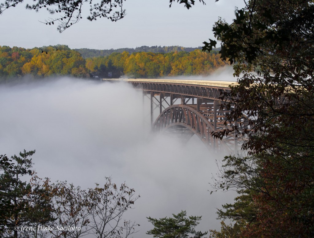
New River Gorge Bridge emerging from fog.
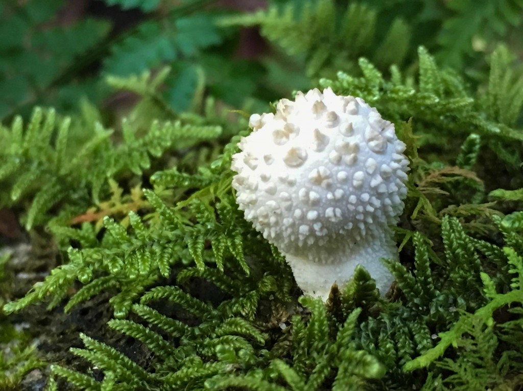
Cell phone shot of a mushroom along the trail to the canyon rim.
Babcock State Park and Glade Creek Grist Mill
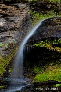
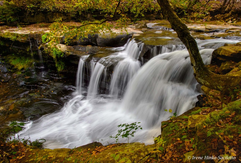
The park is approximately an hour drive from Beckley, WV on back roads. I typically time my travel to arrive shortly after sunrise. This year mill’s water wheel was not turning due to damage caused by a severe flood in June. It is more likely to be operating in the spring when there is more water flowing in the adjacent creek. As with most of the locations visited this fall, the color of the surrounding trees was not intense, However the mill with the falls below still presents a number of interesting photo opportunities from both sides of the creek. Soft light is best at this location since on a sunny day as the sun moves higher in the sky, the contrast between the trees surrounding the mill and waterfalls intensifies. During this visit, I looked for subjects other than the mill to photograph, such as softly lit sections of the creek and colorful reflections in the water.

Glade Creek Grist Mill.
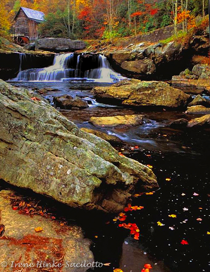
Glade Creek Grist Mill. Photo taken a number of years ago with better fall color.
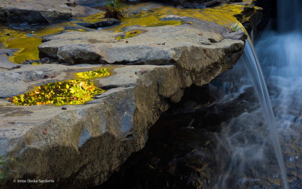
Reflections in puddles from surrounding trees. Falls at Glade Creek Grist Mill, Babcock State Park.
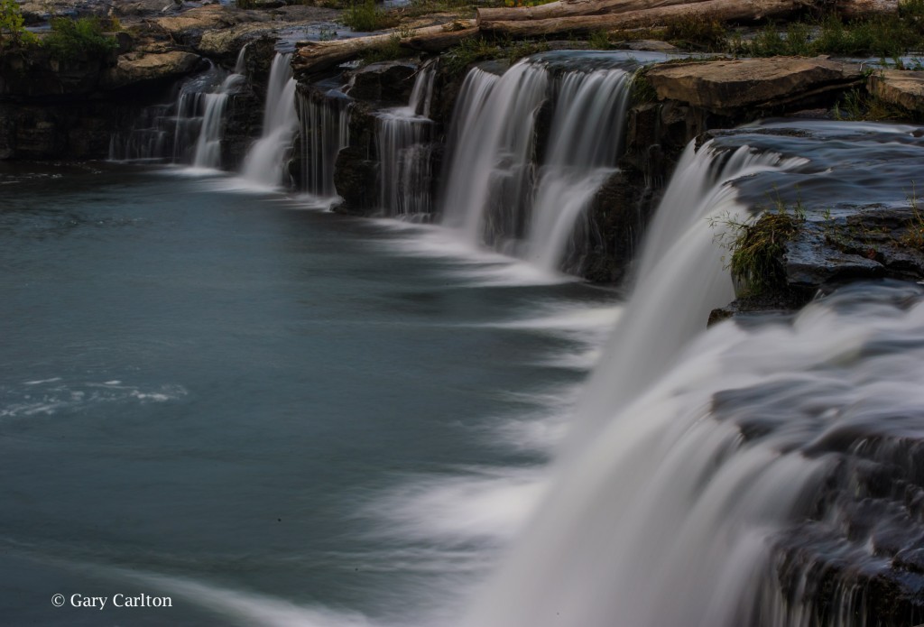
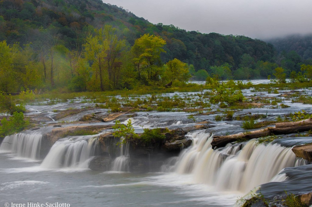
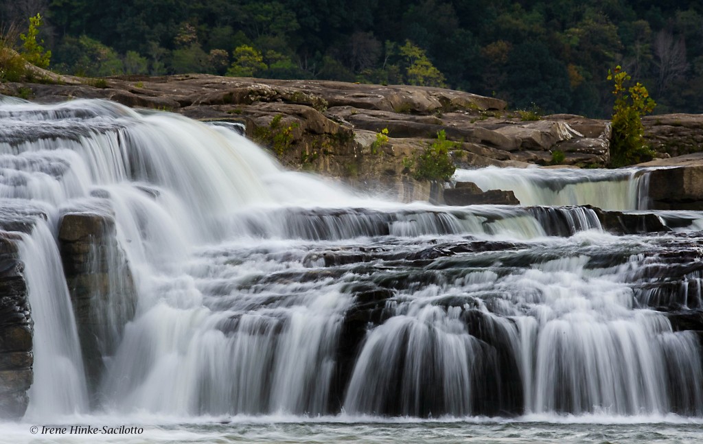
Sandstone Falls
Sandstone falls is the largest waterfall on the New River. Located at a wide point in the river where it is divided by a series of islands, the river drops 10 to 25 feet. A boardwalk with overlooks span the waterways and offer a number of views of cascades and main falls. The first overlook is my favorite, where there is a series of small falls fanning out in a horseshoe shape. There are places to photograph both from the boardwalk and river bank. Access to the higher upper falls is not always possible dependent on the water level.
To reach this section of the National Park, go to the small historic town of Hinton where you cross the New River and travel parallel to its path until you reach the park. (Approximately a one-hour drive from Beckley.) A neutral density filter will enable you to slow shutter speeds for an artistic presentation of the water’s flow. These filters are neutral gray and reduce the amount of light entering the lens. Some are variable in strength and therefore are more versatile. Remove your UV filter before mounting these or a polarizer on your lens Besides extra layers of glass that can soften your image and contribute to flare, when using a wide-angle lens, vignetting of the image can occur (darkening in the corners of the frame). Each time I have visited the park, photographic opportunities differ. As I was leaving the area this time and heading back to Hinton, I noticed the backlit spray of water from the main falls and foreground trees and took the photo below.
Intrigued by the backlit spray from sandstone falls and the foreground trees, I could not resist taking this photo.
The above photo was taken by one of my 2016 workshop participants, Gary Carlton. He used a variable neutral density filter to for the first time to blur the movement of the water. Pleased with the results, he submitted this image during the critique portion of the program.
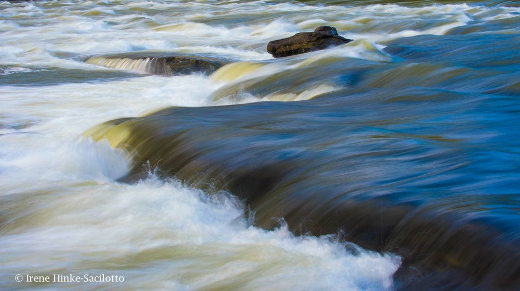
New River downstream from the main falls photographed with a slow shutter speed.
Foggy morning at Sandstone Falls.
Hawks Nest State Park
Hawks Nest State Park offers views of the New River from the side of the river opposite from the Canyon Rim visitor’s center. From Hawks Nest Lodge and overlooks from further down Route 60, there are interesting views of the river and surrounding mountains from a high vantage point. Also there is an aerial tramway to transport you from the lodge to the river below. When you reach the bottom jump off point, you can cross a small bridge and following an easy trail upstream to Turkey Creek Falls. Along the way you can capture photos of the trees gracefully overhanging the river, mushrooms, and wildflowers. Just before the Hawks Nest Dam, you reach a small bridge crossing the creek at the base of the falls. From the bridge and rocks below the falls, you have a good vantage point for photos. The best images of the falls have been taken in the spring when the flow of water is greater. During my visit this October, the flow was minimal.

Shot with the cell phone below Hawks Nest on the trail to Turkey Creek Falls. I used it to show workshop participants photo possibilities along the path to the falls.
Cathedral Falls
If you continue driving down Route 60 from Hawks Nest State Park, just before the town of Gauley Bridge, you will see Cathedral Falls on the right side of the road. Best photographed with late afternoon light. When the sun is high in the sky, there is too much contrast from the upper part of the falls to the base for a good exposure. I recommend using a telephoto lens to isolate portions of the falls, a 80 – 400 mm or 70 – 200 mm zoom lens. On the day of this year’s photo workshop, I spotted a rainbow reflecting in a portion of the falls. It would appear and disappear depending on where one was standing and only lasted for a brief period of time. Several workshop participants got great shots of the phenomena. During my scouting trip, the sky was slightly overcast and the rainbow was not present. But I still was able to capture the etherial beauty of the falls by isolating a section and using a slow shutter speed. Note: Typically I do not photograph with workshop participants during a weekend program, preferring to direct all my attention to helping them achieve the best results possible.
Cathedral Falls in soft light. The most beautiful portion of the falls captured with a telephoto lens.
Kanawha Falls
A short distance down Route 60 from Cathedral Falls is the small town of Gauley Bridge which provides access to the river for photos of reflections in the flowing water and of geese along its bank. Just southeast of Gualey Bridge is Glen Ferris where Gualey River and New River converge. Here you will find Kanawha Falls adjacent to a hydroelectric station. From a trail used by fishermen parallel to the main road, you can isolate a portion of the falls with a telephoto lens and exclude any evidence of the power plant. As an alternative, you can photograph the aging brick power station for a graphic image.
Kanawha Falls photographed with telephoto to isolate falls from its surroundings
Town of Thurmond
The historic town of Thurmond was once an active railroad town like many located along the New River. It can be reached off of Rt 19 at Glen Jean Exit north of Beckley. A narrow winding road leads to the town following a stream that cascades down the mountain. On the way down, there is a pull-off that provides relatively easy access to photograph one of the larger cascades.
At the base of the mountain, you reach the historic town of Thurmond by crossing an old narrow railroad bridge that spans the river. Ahead you will see a parking lot and railway station renovated by the National Park Service and serving as a Visitors Center. What makes this location special is that railroad tracks run through the center of town. Today only a few buildings remain from the past. However with a wide-angle lens, the train tracks create great lines leading into the frame. If you are there at the right time, you may be able to photograph a train as it approaches. Watch the signals above the tracks for an indication that one is on its way.
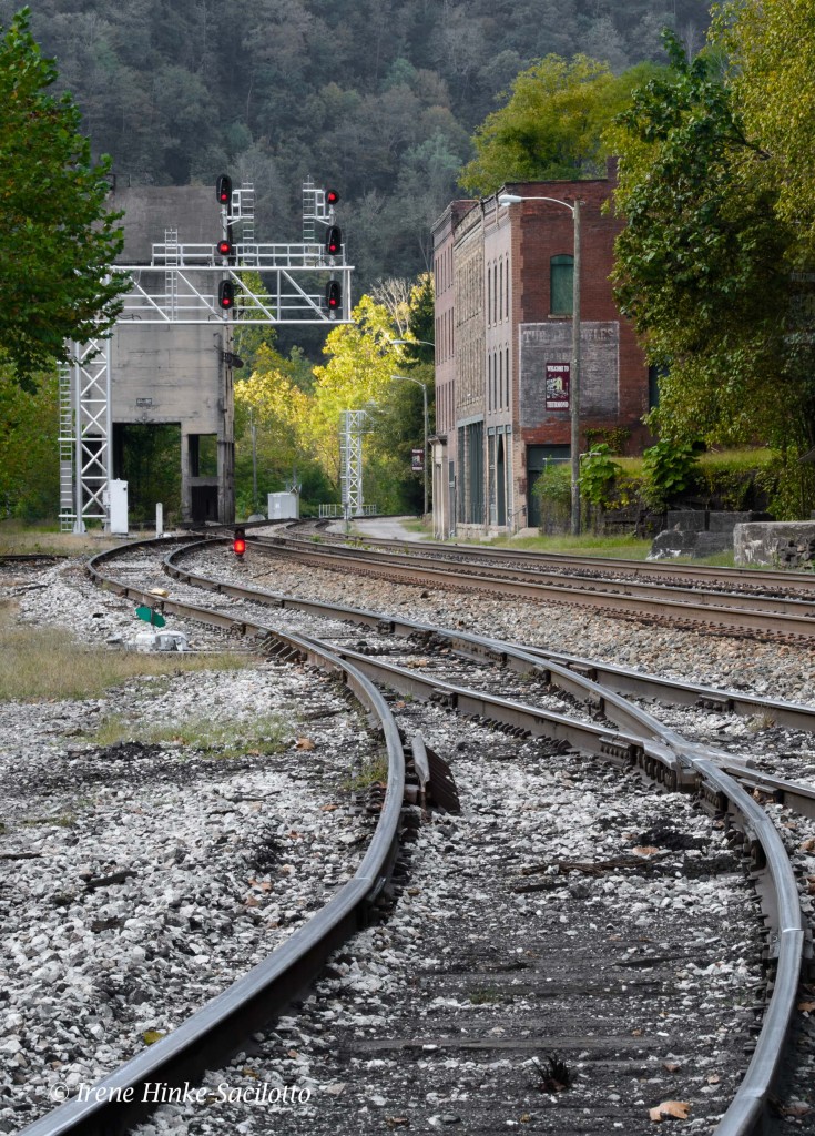
Railroad tracks at Thurmond.
Cascade on way to Thurmond.
Grandview, part of the New River Gorge National River, NP
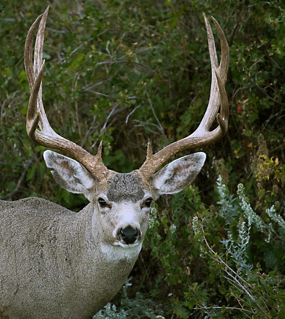
Grandview lies within the National Park and provides views of the horse-snapped section of the river from 1400 feet above. In the early morning interesting shots can be obtained as the fog slowly lifts from the canyon floor revealing the river below. A trail follows the rim with a few small overlooks which are partially blocked by vegetation. Another overlook farther along the canyon wall is Turkey Spur. Steps lead to viewing platforms, but this year the upper level was closed due to fire damage. In May and June, I understand the area is quite beautiful with blooming rhododendron along the trails. This year there was little fall color but I did take an abstract photo of the forest by zooming my lens during a slow exposure. As I exited the park, I grabbed this photo of a white-tail deer.

Deer photographed just outside of Grandview.

Fall color at Grandview captured by zooming my 70-200 mm lens with my camera set on a slow shutter speed.
Fayetteville Station Road
The 100 year-old Fayetteville Station Road once regularly traveled before the modern New River Gorge Bridge was built in 1977. Access to the road is off of Rt 19 by turning right on Lansing-Edmond Road, near the Canyon Rim Visitors Center. Once on this narrow road, turn right at the sign “Fayette Station Road” and immediately take the left fork. This road is a very narrow with hairpin curves and sections that are only open to one-way traffic. It passes under the current bridge twice, offering unique views of the steel structure. Also it provides access to the banks of the New River, several small waterfalls, and Kaymoor trail which passes a historic coalmine site. The road is worth the drive but is closed to traffic during Bridge Day weekend when the New River Bridge is closed to vehicles an open to pedestrian traffic and BASE jumpers.

New River Gorge Bridge’s steel structure photographed underneath on Fayetteville Station Road.

By selecting sections of the bridge’s iron work, you can create interesting abstract photos.
Nuttallburg Town
Nuttallburg was one of a number of bustling coal mining towns along the New River. The abandon townsite for years was concealed under the cover of trees and vines. It was recently restored by the park service and can be reached from Lansing-Edmond Rd by turning right in the community of Winona onto Keeneys Creek Road. This very narrow road descends into the gorge to a parking area. From here, trails lead to the foundations of buildings and remains of coke ovens that converted the coal into fuel. The most interesting aspect of the site is the coal tipple and conveyor that transported the coal from the mine up the mountainside down to the processing area and railroad below. On a bright sunny day, the scene is difficult to photograph without using HDR technology. The contrasty photo below was taken this fall at mid-day while scouting locations to determine which to include in my upcoming workshop.
Coal conveyor at Nuttallburg Town. The amount of contrast in the scene was high resulting in distracting deep shadows and burnt-out highlights.. It would be best to photograph this scene when the light is softer.
Side of the old tipple in Nuttallburg Town I was attracted to the colors, shapes, textures, and lines displayed by the wall and took this photo of the abstract design. The side of the building was shaded, perfect for this photo.

by Osprey Photo Workshops & Tours | Nov 6, 2016 | Autumn photography, Fall photography, Nature Photography, North Dakota, Photo Tour, Photo Tours, Photo Workshops, South Dakota, Wildlife, Wildlife Photography

NORTH AND SOUTH DAKOTA BADLANDS, Trip Report, September 2016.
While scouting locations with Sandy Zelasko and preparing for our spring workshop, we visited both the Badlands in North Dakota (Theodore Roosevelt NP) and the Badlands and Black Hills in South Dakota.
Badlands in North Dakota, Theodore Roosevelt NP.
The Badlands of THEODORE ROOSEVELT National Park (NP) in North Dakota were impressive but not as colorful as those in South Dakota. However some eroded formations were unique including spheres and other oddly shaped rocks balanced on top of ridges or embedded in canyon walls. My favorite subjects were the wild horses, which we encountered in several locations. In North Dakota, the wildlife was not as visible or easy to photograph as in South Dakota Badlands where we found bighorn sheep, pronghorn antelope, mule deer, prairie dogs, buffalo, turkey, grouse, and in the past, badger. From our modest but comfortable motel (Cowboy Inn) in the town of Belfield, ND, we were approximately a 20-minute drive from the southern entrance to the park and an hour from the northern segment. Both areas are worth visiting. However after comparing our experiences in both North Dakota and South Dakota, we decided that the best photo opportunities with a mix of wildlife and landscape photography was in the South Dakota Badlands where we will offer our next photo workshop in early June 2017.
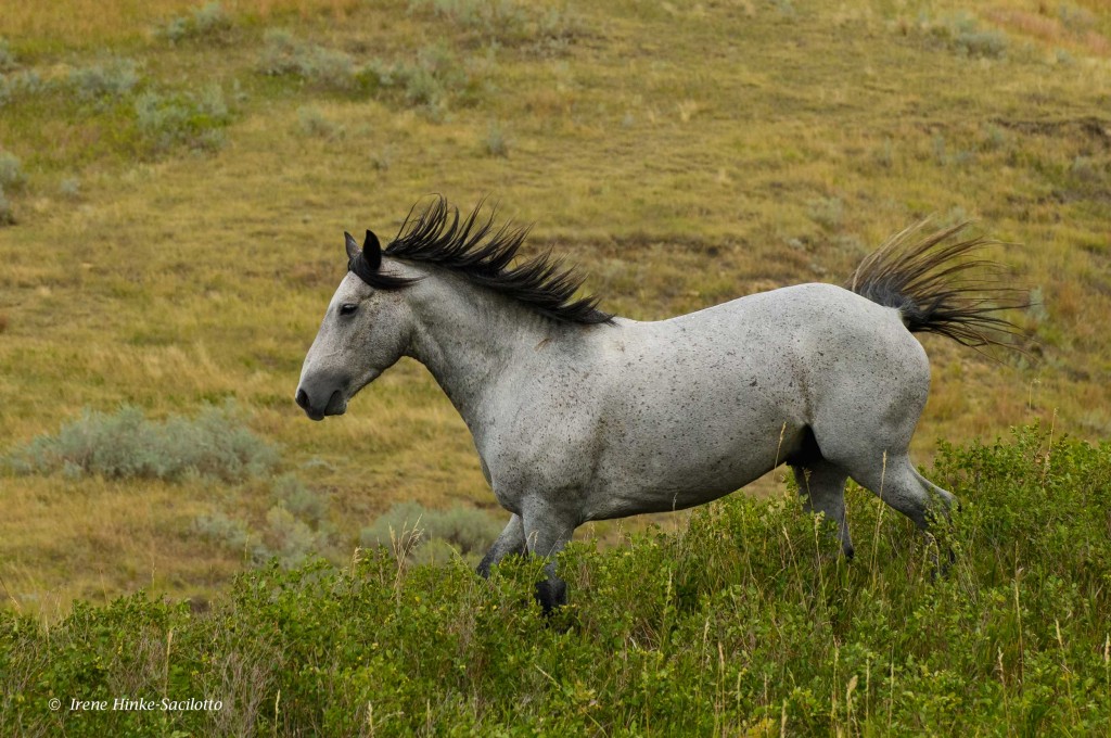
Wild horse

Deer a field in North Dakota
North Dakota Badlands with slanted rock.

Buffalo at sunset.
A paved road loops through the 24,000 acre Badlands NP in South Dakota with scenic overlooks and traveling between the sharply eroded buttes, pinnacles, pedestals, and spires and undisturbed mixed grass prairie that characterizes the park. The badlands were formed from alternating layers of hard and soft rocks and soil. Easily eroded materials such as clay or mud-stone is topped by more resistant materials, such as sandstone, with the harder horizontal layer protecting the soft deposits. There are a number of hiking trails to provide a closer look at the unique geology of the region. North, Door and Window trails near the North East entrance to the park meander amongst the formations, for an up-close and personal look at the rocks layers.
Yellow Mounds
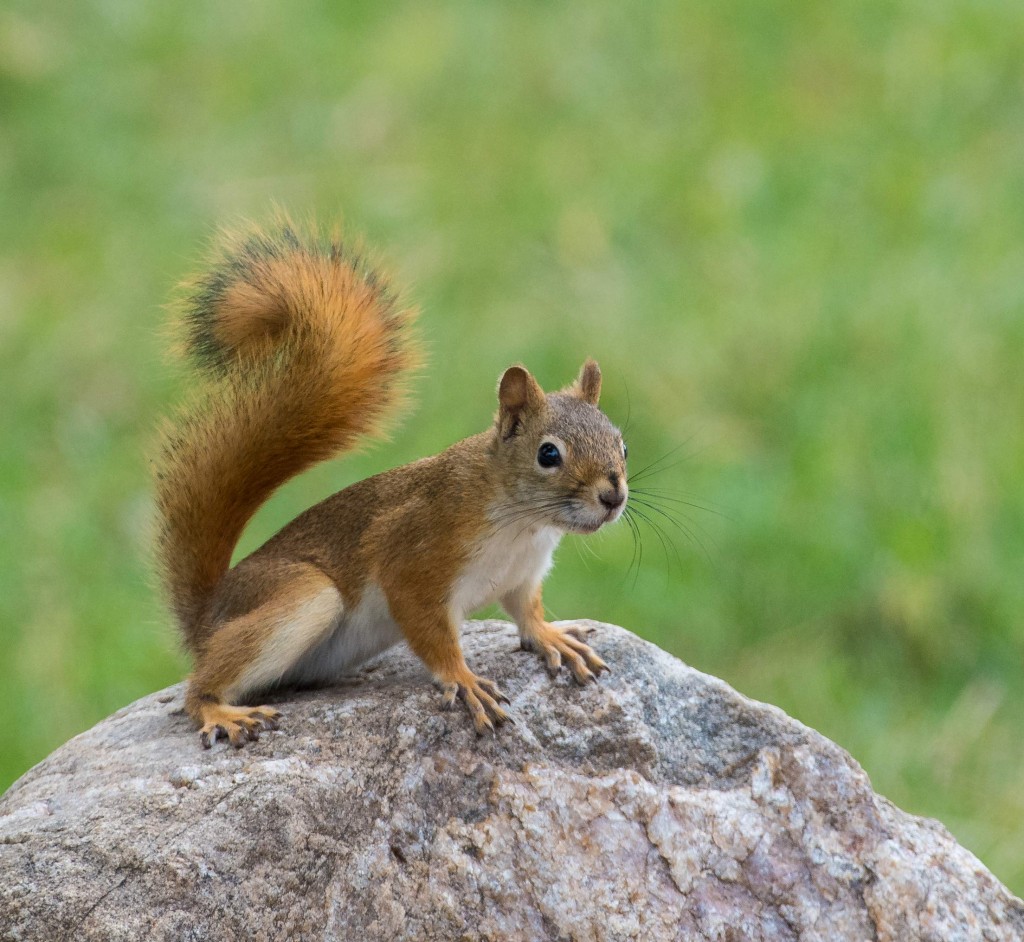
Red Squirrel
It s hard to pick a favorite location for photography within the park since there were so many sites to choose from. I loved the sulfur mounds and eroded formations near Dillon Pass and Conata Basin but was equally fascinated by the alternating tan and rusty bands of color from oxidized iron near Saddle Pass Trail. Southern views from Sage Creek Rim Road also offered great opportunities for landscape photography with deep ravines and colorful mounds eroded by wind and rain. Along the
gravel road is a good place to spot wildlife in and about Roberts Prairie Dog town. Buffalo, pronghorn, and bighorn sheep graze on the grasses while coyotes stalk unsuspecting prey. It was here I photographed a badger at close range during my last visit. Actually the best place this year for prairie dog shots was along a less traveled dirt side road running north as you head east past Contata Road and Dillon Pass. With little disturbance from traffic, the prairie dogs were more cooperative and allowed us to shoot belly down on the ground. More remarkable, along the same road, a coyote slowly walked towards our car and crossed the road in front us into the grassland paying little attention to the sound of our cameras firing off a burst of shots.

Bighorn Sheep
Sheep Mountain Table in the Southern Stronghold area of the park is worth a visit if you have a car with high clearance able to climb the steep dirt road that leads to the top of the mesa. It’s a peaceful place with few visitors where you can enjoy views in all directions from the high vantage point. On the Western edge of the Badlands on the way to the mesa from Sage Creek Rim Road, Scenic is a nearly abandoned town off the main highway that offers you a glimpse in the past with unique photo opportunities. Here you can photograph your friends behind bars in a historic jail or in front of the once lively Longhorn Saloon where steer skulls line the roof of the building. If you look hard at the sign on the face of the building, you will notice a somewhat disturbing message indicating who was welcome. If you look hard, the first word “NO” is painted over.
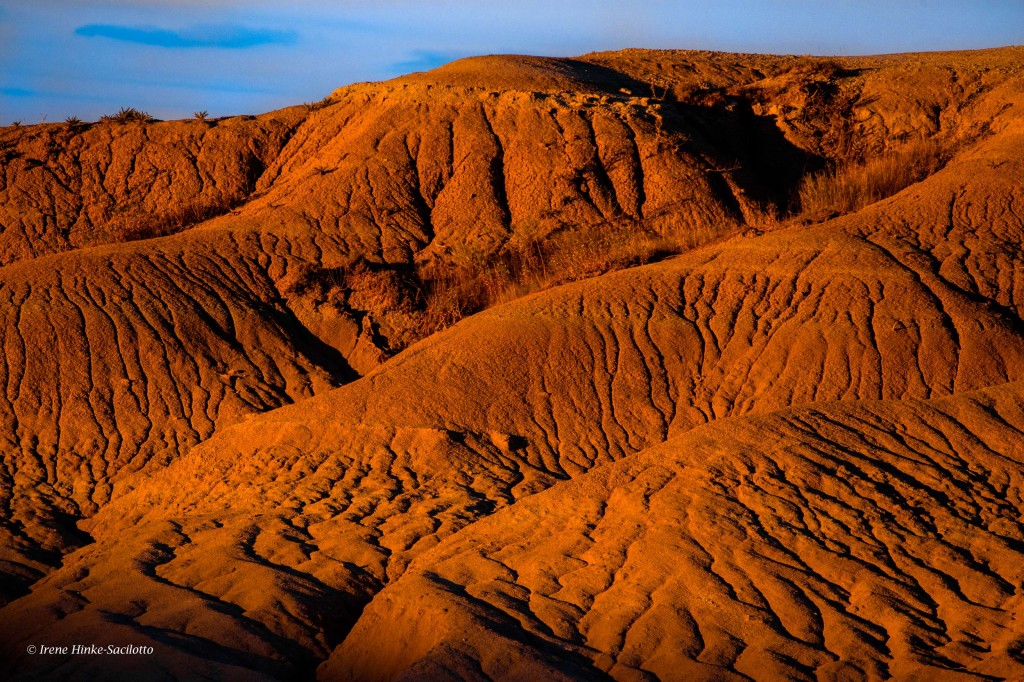
Eroded mounds at Sunset
GIGANTIC FIELDS OF SUNFLOWERS. On the first leg of the trip, Sandy and I explored the back roads from Rapid City to Belfield, ND, where we stayed while exploring the area. From there headed south to Wall and the Badlands of South Dakota. Along route 73 south of Lemmon and elsewhere, we discovered huge fields of sunflowers, much larger than any I have seen in Maryland. Although some flowers were past their prime, we stopped to take photos of several fields in prime condition with macro, telephoto, and wide-angle lenses. Surprised at the number and size of the fields, I checked the Internet to find that this area is one of the highest producers of sunflowers in the U.S. The seeds are used in the production of sunflower oil as well as for consumption by humans and birds.
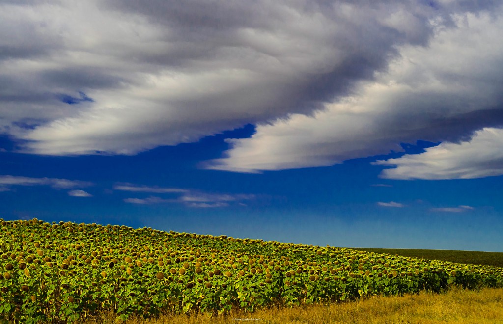
Sunflower field

Marmot
It was 13 September, not a holiday weekend, when we entered the southern gate of CUSTER STATE PARK and encountered bumper-to-bumper traffic on the loop road. There were several tour vehicles with park visitors and accompanied by guitar-playing singers. Needless to say, this was not the environment I had remembered from past visits. Instead of the “wild” burrows grazing on the hillsides and dusting in areas devoid of grass, they gathered on the road, sticking their heads into car windows and begging for food. Also there were more fences than I remember from a previous trip limiting photography in certain areas, but we were told the fences were there to protect sensitive habitat from overgrazing. As we moved further along the loop road the situation improved. We did encounter a large herd of buffalo, lots of bluebirds, a few mule deer, bighorn sheep, and pronghorn. Our favorite areas were along the gravel roads that branched off the main route. Here there was little traffic and the rolling hills were beautiful particularly on the route that led into the backcountry of Wind Cave NP. We encountered buffalo, herds of pronghorn, and the possibility of seeing elk. We found photographing in Wind Cave National Park was more productive with pronghorn on hillsides, energetic red squirrels retrieving and storing pinecones for the winter, wild turkey, and mule deer adjacent to the road.
Needles Highway in the Black Hills not far from the town of Custer includes 14 miles of sharp turns, low tunnels and impressive granite spires. It is a good spot to look for mountain goats, which are known to frequent the high country near Cathedral Spires and Needles Eye Tunnel. They have even been photographed inside the tunnel licking minerals from the rock walls. With little time remaining on our scouting trip, we drove the highway one morning in search of goats but when a heavy fog engulfed the Needles, we could hardly see the car in front of us let alone spot their white coats. The highlight of the drive was witnessing a full sized tour bus carefully position itself and pass unscathed through Needles Eye Tunnel while the extended side mirror of a pick-up truck that entered before the bus scrapped the inside of the wall.

Tour bus
We made a short side trip to Spearfish Canyon on 16 September. We were a bit early for fall color in the canyon, which I had enjoyed on a previous trip. The waterfalls were impressive particularly Roughlock Falls. Bridal Veil falls had little flow and would have been more impressive if it was surrounded by fall color or snow covered trees. Spearfish Falls is near the Southern entrance to the canyon and is photographed best in soft light in the early morning.
NOTE: You are likely to encounter the best leaf color in the South Dakota Badlands and Black Hills the last two weeks of September.
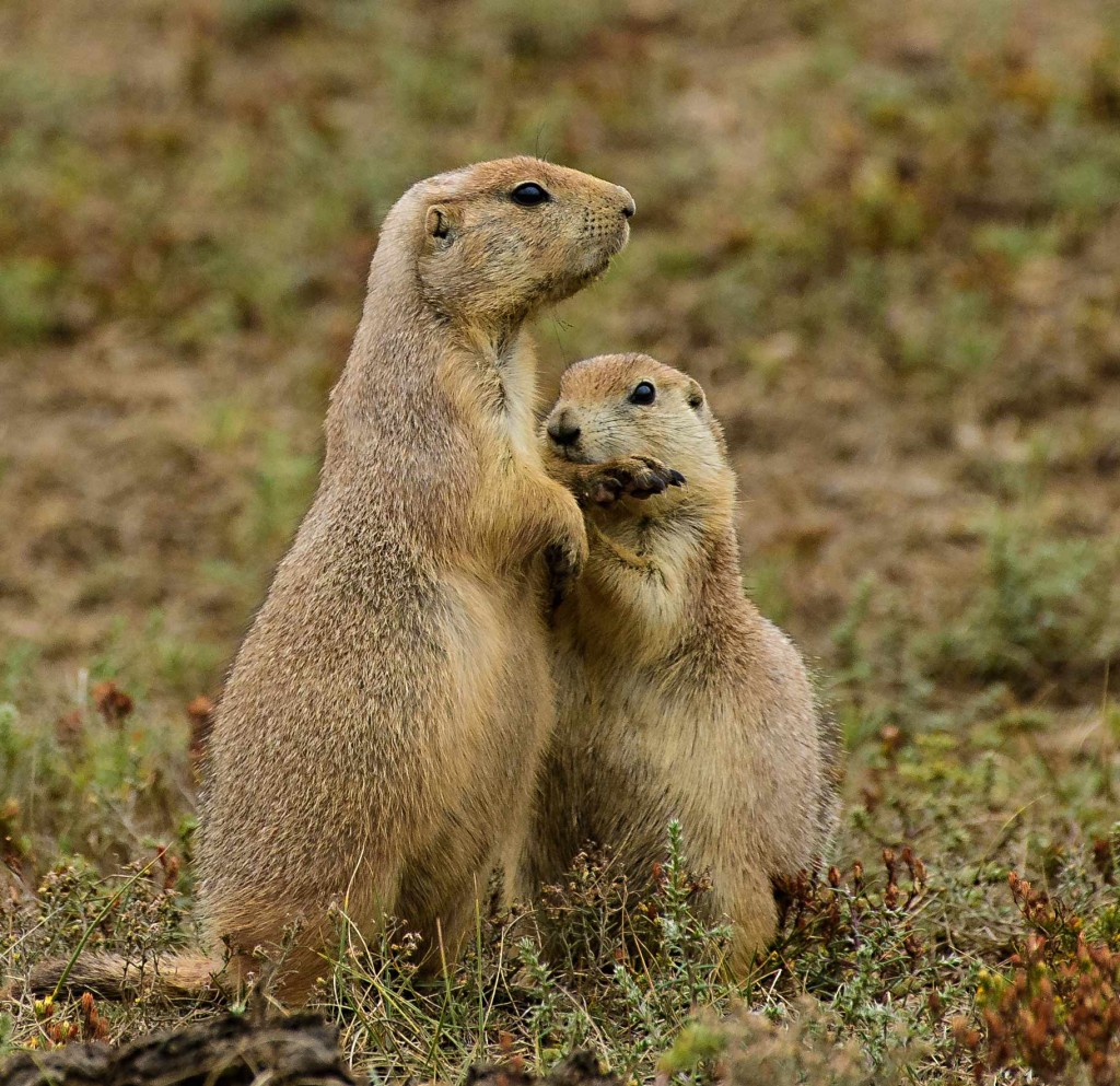
Praire Dog biting paw.

by Osprey Photo Workshops & Tours | Aug 22, 2016 | Bird photography, Brazil, International photo tours, Nature Photography, Photo Tour, Travel, Wildlife Photography
Brazilian Pantanal photo tour–sights, photo tips, equipment, challenges.
I have been to the Brazilian Pantanal twice in the past, once on a scouting trip and most recently conducting a photo tour. In both cases, I worked with an excellent naturalist/guide/photographer who I have known for more that twenty years, Alejandro Ronchetti of KÚntur Expeditions based in Buenos Aires, Argentina.

Hyacinth Macaw
On this past trip, we flew from Dulles Airport non-stop to São Paulo and then on to the city of Cuiabá where the tour started. After a good night’s rest, we left the city in a van and headed southward, stopping briefly in Poconé for supplies before entering the Transpantaneira Highway. During the tour, we stayed overnight on two eco-friendly ranches and at the hotel Pantanal Norte at Porto Jofre. Along the Transpantaneira Highway, it was relatively easy to spot birds and other wildlife. We stopped frequently to take photos. The number of birds seen on the trip was unbelievable with remarkable numbers of snail kites and hawks in addition to many colorful birds. At one of the larger bridges, we had the opportunity to photograph a large assortment of birds–limpkins, spoonbills, herons, kingfishers, anhinga, and other birds feeding in the marsh below.
Our first stay was at the Pouso Alegre Ranch. Although the rooms were modest, the food was good, and wildlife abundant. At dawn, just outside our room were agoutis (small rodents), Southern Lapwings, rheas, toucans, and several curassows. Close to the lodge was a marsh and lagoon that straddled the road and was populated with a large number of herons, kites, kingfishers, and hawks. During the day, caiman congregated at the end of the lagoon and sun themselves on the road. One of the most unusual birds was the capped heron with a striking blue bill that was feeding along the bank in the vicinity of a a number of caiman. As we explored the ranch roads, we had the opportunity to photograph coatimundi, brocket deer, ibis, and jabiru storks. The tapir we were hoping to see eluded us, leaving only it tracks behind in the mud.

Sayaca Tanager
After 3 days on the ranch, our next stop was the riverside hotel at Porto Jofre where we had the best chance to see jaguar. The accommodations were modern and very nice with an assortment of birds just outside our rooms– buff-necked ibis, hyacinth macaws, caracaras, chaco chachalacas, toucans, just to name a few. Behind the rooms was a boardwalk leading past giant lilies and other marsh species. Twice a day for 3 days we navigated the Cuiabá River and its tributaries at Parque Estadual Encontro das Aguas (Meeting of the Waters) State Park in search of jaguar and other wildlife species. Here jaguars are protected and openly hunt spectacled caimans, capybaras, tapirs, and other animals along the riverbanks. This magnificent cat is the largest in South America and is a proficient swimmer and with its strong jaws can easily crush the skulls of its prey. Although never witnessing a kill as we had hoped, we had several opportunities to photograph jaguar relaxing and walking along the riverbank. In each case, the light was low and the animal was often in heavy shade requiring ISO settings of 1250 and above. Our boat was stable and large enough for the four of us plus Alex and our photo gear. With care, I was even able to use my 600 mm, F4 lens mounted on a tripod to photograph jaguar and small birds. Our boat driver was proficient positioning us for the best photos and was in radio communication with other guides, so when a jaguar was spotted, we knew the location. In most cases, when a jaguar was located, 4 or 5 boats would eventually arrive at the location and anchor at a distance off shore to observe the cat that seemed to be oblivious to their presence. Later in the season, when there are more tourists, I suspect the number of boats would be greater. Besides jaguar, we photographed other wildlife including giant otters, capybaras, caiman, yellow-billed terns, a pied lapwing, kingfishers, and more.

Jaguar
Our last stop in the Pantanal was two days at Fazenda Santa Tereza ranch. Here we encountered a crab eating fox, hummingbirds, yellow-chevroned parakeets, a rufous-tailed jacamar, and other birds at feeder and near the lodge. From outside our rooms and from a scaffold near the nest, we could watch a pair of jabiru interacting and fortifying their nest. We were taken to see a great potoo at its daytime roost. It was so well camouflaged as part to the tree, that it would have been nearly impossible to see without a guide. Each day we explored the river adjacent to the inn by boat and photographed black-collared and black hawk, ringed kingfisher, and herons, snatching up fish tossed in the water.. During our exploration of the river, we photographed anhinga, a sun bittern, jabiru storks, river otters and a spectacular sunset. The Pantanal was well worth visiting and I would love to return.
Added to the Pantanal trip, we had an excursion to Chapada dos Guimarães, a national park with picturesque tablelands located 65 km northwards from Cuiabá. The highlight of the visit was the Veu da Noiva Waterfall from where we could admire the tablelands and one of the highest waterfalls of the park. Of particular interest was the opportunity to photograph red-and-green macaws flying in front of the falls and canyon walls. The Pousada do Parque Lodge where we stayed was lovely with many birds visiting the grounds early and late in the day. It was the perfect place to relax at the end of the tour. However for serious landscape photography, the park was disappointing since visitors only have access between 9 AM and 5 PM, not the best time for extraordinary light and dramatic images.
On a previous trip, we flew from Cuiabá to Campo Grande and drove to the town of Bonita with access to the Southern Pantanal. The highlight of our visit was the huge sink-hole, Buraco das Araras, where red and green macaws nest. Loved it.
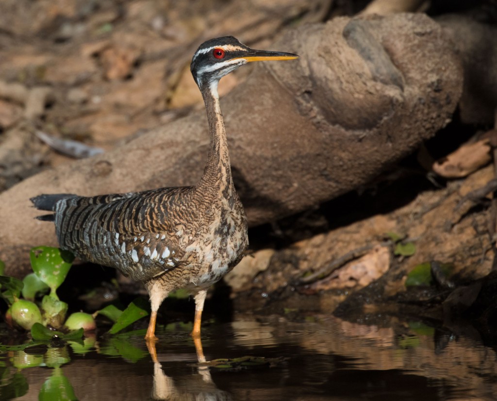
Sun Bittern
Lighting challenges:
The variety of birds seen was mind-boggling but lighting was not always optimal. Although on the road early in the morning and late in the afternoon when the light was warm and soft, we were also in the field when the sun was higher in the sky and the light was harsh, washing out colors, obscuring details with dark shadows, and contributing to distracting backgrounds. Since I wanted to capture the range of animals for a program on the Pantanal, I took chances on shots that required more editing than I prefer to minimize problems. The best photo opportunities during non—prime hours were when a light layer of clouds softened the light or when the subject was in open shade. However in the later case, images tend to appear flat and colors slightly muted. To compound the periodic lighting issues when shooting in jungle or forests, there were vines, branches, light colored grasses and other vegetation either in front of subjects or contributing to an undesirable background that could not be avoided. But remember, this is the real world and not a photo studio.
Equipment:
It is always a challenge to transport camera equipment on the plane. I use a Gura Gear light-weight photo backpack but it appears large on my small frame. I am always concerned bout having the bag taken away from me and placed with checked luggage. Airline personnel have challenged me on several occasions, but they reluctantly allowed me to keep the bag once I explained the delicate nature and cost of the contents.
On this trip, I took my Nikon 600 mm, VR, F4 lens. It is quite heavy and large. When shooting from a car window on a large beanbag or on a tripod, the lens is wonderful for photographing small subjects and I will continue to use it for these applications. But from the confines of the van with other photographers, the lens was difficult to maneuver and nearly impossible to hand-hold. When exiting the van and mounting the lens on a tripod, I lost precious time positioning the lens and missed a shots I may have gotten with a smaller, lighter rig . Today, its large front element and high light gathering capacity is less critical than in the past now that high end cameras such as Nikon’s D5 perform fairly well at high ISOs, producing less noise (similar in appearance to film grain) as in the past. Note: Problems with noise is magnified when underexposing an image. After observing the ease of handling and quality of several lighter and less expensive zoom telephoto lenses carried by fellow travelers, I just purchased Nikon’s 200-500 mm zoom lens for increased flexibility. Although lighter that the 600 mm, this lens is still not a feather-weight. We will see how well it performs on my next photo excursion.

Red and Green Macaws
Besides the afore mentioned lens, I took with me a Gitzo carbon fiber tripod with Arca Swiss head, 35 to 70 mm zoom lens, an 80 to 400 mm zoom lens, 62 and 77 mm polarizers, Nikon D5 and D4s cameras, spare batteries, charger, empty beanbag, 32 and 64 G fast compact flash cards, Apple MacBook Air computer and two Seagate Backup Plus 2 T portable drives for image storage. For the Pantantal, insect repellant and sunscreen are a must. Dehydration is always a consideration when spending hours in the sun on an open boat so carry an adequate supply of water. I have a water bottle with a mister attachment. Not only can I drink water from the bottle but I can also spray myself with water to cool down quickly.
Timing of my trip:
On both trips to the Pantanal, I arrived in late June and stayed until mid-July. The water level is still dropping after the wet months. Less bank is exposed compared to later in the season, making animals a little more difficult to see and photograph. Accommodations in the Pantanal are limited, so it is imperative to make reservations early. Later in the tourist season, available rooms in the best locations are more difficult to find.
Flight info:
I booked my flights to São Paulo and Cuiabá on-line directly with United Airline (the flight to Cuiabá on GOL, a partner airline). I was issued both boarding passes at the United Airline desk and our bags were checked in all the way to Cuiabá. Therefore when I retrieved my checked bags after my US flight and passed through customs, I could immediately re-check them for the remaining flight.
Coming home there was 10 hour lay-over in São Paulo Airport, so checking the bags right after the arrival of the domestic flight was not possible. Therefore we rented small rooms on a hourly basis at hotel in the airport called FastSleep. This allowed us to survive the layover comfortably, being able to nap, catch-up on e-mail, exercise by walking throughout the terminals, and pick up last minute gifts. After observing the experience of one of my fellow travelers, next time I will reserve a room using Booking.com as opposed to dealing with the hotel directly.

Great egret