
by Osprey Photo Workshops & Tours | Aug 8, 2021 | Autumn photography, Chincoteague NWR, Nature, Nature Photography, Photo Tours, Photo Workshops, Wildlife, Wildlife Photography
Trip Report, Chincoteague NWR, November 2020
Nature Photography
Chincoteague NWR is located on the southern Virginia end of the barrier island of Assateague. In the fall, the refuge attracts large numbers of snow geese along with ducks, swans, herons, ospreys, shorebirds and other migrants. It is also the home to wild horses, deer, raccoon, fox squirrels, and other animals. Used to being protected, the wildlife is unusually tolerant of humans and presents visitors with great photo opportunities. It is one of my favorite places to photograph wildlife in both the fall and spring. I have been conducting photo workshops there for many years. Numbers of species and the variety has shifted over the years. The refuge is located along the Atlantic Flyway. Once over 40,000 snow geese stopped at the refuge doing fall migration Now they stop farther north but still several thousands visit the refuge today along with shorebirds, swans, and other waterfowl.


Chincoteague NWR website:
https://www.fws.gov/refuge/chincoteague/
Trip report – Fall 2020
First Stop – Sunrise
For sunrise I typically stop along Beach Road at the first large pool on the right after passing the visitors center– Black Duck Pool. There are convenient pull offs for cars on both sides of the road. At sunrise, I often see deer crossing the water.
I had a treat one morning at sunrise when a large flock of White Ibis circled overhead with many landing in front of me. They were joined by herons and a few ducks. When photographing the birds against colored sky and water, I had to be careful that their silhouettes did not merge with the silhouettes of other birds or the surrounding grasses.
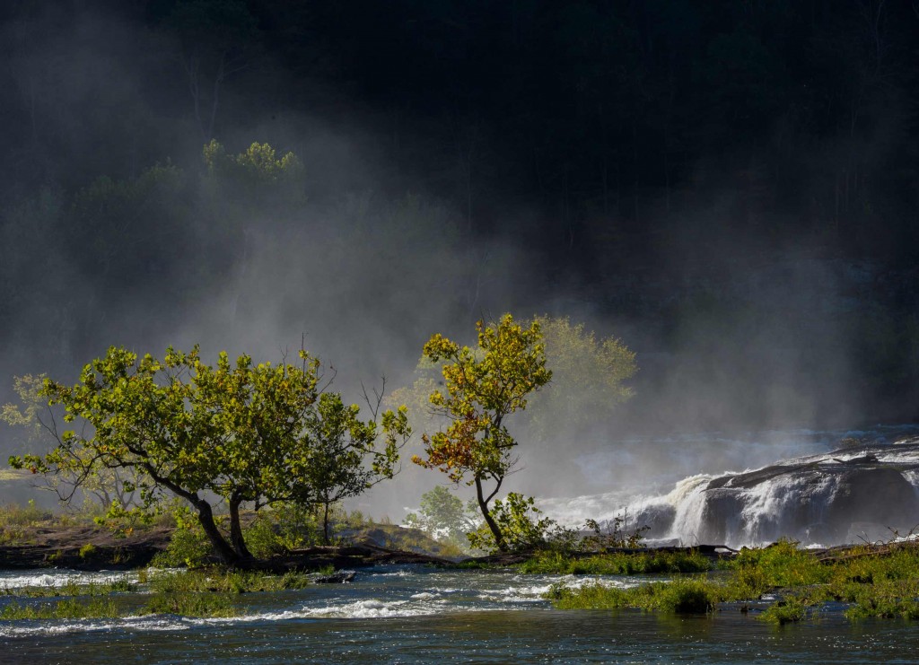
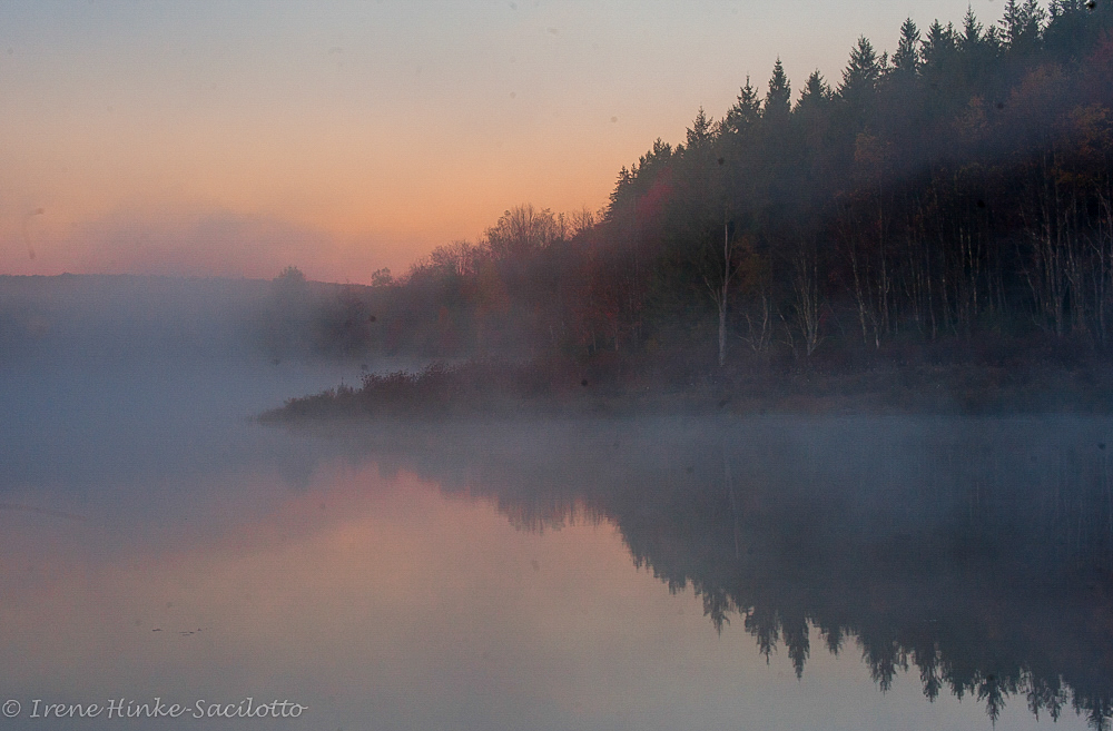
Several mornings were foggy and allowed me to create images different from many I have taken here before at this location. The two photos below were taken on one of those mornings. I like the layers revealed by the lifting fog and sense of calm these images invoke. In terms of exposure if using aperture priority, I had to increase my exposure compensation by at least +2. Remember that the light meter assumes it is pointed at something mid-tone and will darken the exposure to make it so, thereby underexposing the image.


First Stop – Sunrise
For sunrise I typically stop along Beach Road at the first large pool on the right after passing the visitors center– Black Duck Pool. There are convenient pull offs for cars on both sides of the road. At sunrise, I often see deer crossing the water.
I had a treat one morning at sunrise when a large flock of White Ibis circled overhead with many landing in front of me. They were joined by herons and a few ducks. When photographing the birds against colored sky and water, I had to be careful that their silhouettes did not merge with the silhouettes of other birds or the surrounding grasses.
Several mornings were foggy and allowed me to create images different from many I have taken here before at this location. The two photos below were taken on one of those mornings. I like the layers revealed by the lifting fog and sense of calm these images invoke.

In terms of exposure if using aperture priority, I had to increase my exposure compensation by at least +2. Remember that the light meter assumes it is pointed at something mid-tone and will darken the exposure to make it so, thereby underexposing the image.

Black Duck Pool
After shooting sunrise, I will check out the scene across the road for horses and herons in the early morning light. If there is nothing of interest, I typically drive towards the beach checking out the borrow ditches on the side of the road for herons, ducks and other visitor that are in good light and in a suitable non-distractive background.
Note: In the summer it is difficult to photograph wildlife other than in the early morning and late in the pm since there is a lot of traffic on Beach Road as folks head to the public beach for the day.
On the morning that I saw the flock of ibis at sunrise, I found a large number of individuals engaging in a feeding frenzy at the junction between the borrow ditch on the left and Swan Cove. They were joined by a few herons. This is the first time that I have witnessed such a high number of ibis together. When they finished feeding in one area, they moved up the borrow ditch congregating at various points along the way. My car worked beautifully as a mobile blind. I could move the car and follow the birds as they traveled upstream. I shot from the car as to not disturb the birds and used a bean bag on the window sill to securely support my lens and camera.

Occasionally in the same area I have encountered a fox or raccoon, so I am always checking the edges of the road for cooperative subjects.

Swan Cove
One of my favorite spots to photograph is Swan Cove. It typically attracts are large number of birds including shorebirds that often feed in the shallows near the road at low tide. On this trip I encountered a group of Yellowlegs and Dowitchers feeding close to the shore. Again I used my car as a mobile blind, shooting from the window with my 600 mm lens mounted on my home-made beanbag. On a day there was little wind and I was able to capture images of the birds with their reflection in the water. I always look for small ducks and grebes in this pool. On this trip I was able to photograph several tolerant Pied-Billed Grebes, Buffleheads and Ruddy Ducks close to shore, sleeping, preening and diving for food.


Black Duck Pond
Often later in the morning I check out the marsh and fields across from Black Duck Pond. I typically look for horses in the marsh and around small stands of trees. Around 9 a.m. on more than one morning, I got a number of photos as the horses crossed the marsh and fed on the grasses. Sometimes blackbirds would land on their backs, I am guessing, eating insects.

In this same area I found a cooperative female Belted Kingfisher sitting on a post. I spent a delightful hour with her as she flewdown to catch fish, landed on the post again, shook off water, preened. and stretched its wings. I got a number of great images shooting from my car with my 600 mm F4 lens combined with a 1.4 teleconverter


Also in the same marsh where there were pools of water and a channel, I was able to photograph herons feeding, groups of Buffleheads swimming the channel as well as Double-crested Cormorants swimming, diving or sitting on dead snags drying their wings. This past year the water level in the marsh was perfect for shooting across marsh at sunset.

Little Toms Cove
I frequently check out this area near the water control devices that allow water to pass under the road to Swan Cove. Often when you have an obstruction in waterway, macroinvertebrates and other organisms accumulate around the opening often attracting fish and birds. This year I encountered a bird that I had not photographed before, a Surf Scoter, a sea duck typically seen flying over the ocean. This past November there was a Horned Grebe hanging out in the same location. When the tide is out, I often see rails or oystercatchers feeding on the exposed mud flats.


Sea Ducks
In the winter some photographers go to Barnegat Light and State Park in New Jersey, The photographers brave the cold to photograph sea ducks from the jetty at the inlet — a favorite is the Harlequin Duck. I have not visited the site in the winter but have seen great results. However, conditions can be dangerous with icy rocks and a rough surf with waves that might swamp you and your equipment.
 Atlantic Shore
I always check out the beach for a colorful sunrise or shorebirds feeding along the water’s edge. The best time to photography is when the tide is low and when more of the beach is exposed. When photographing shorebirds, in the morning at Chincoteague it is difficult to avoid shadows covering much of the bird without moving out into the surf. However with post processing in Lightroom and Camera Raw, you can lighten the shadows with a selection brush. I always concentrate on birds that are moving towards me, not retreating. In the afternoon, it is easier to capture these images since the bird often is lit by the soft warm light at the end of the day.


 x
x
Bayside
On the bayside of Little Toms Cove opposite the beach, I often find an assortment of shorebirds, herons and an occasional fox. On this visit, there were Great Egrets flying back and forth feeding near posts marking private clam beds. I also photographed aa Black-bellied Plover and a Dunlin in winter plumage feeding amongst the oddly colored organism called Sea Pork. It is a colony of tunicate organisms which are plankton feeders. Though an oral siphon, they draw seawater through their bodies and pass it through a sieve-like structure that traps food particles and oxygen, eventually to exit through the atrial siphon. One sunset when the tide was out, I captured the remarkable colors and patterns as the setting sun lite the mud flats.


Wildlife Loop
On fall afternoons, I often checked out the wildlife drive around Snow Goose Pool (only open to cars after 3 pm). This time not long after I entered the drive, I saw a flock of ducks explode in flight from the marsh. It took me a minute to realize that a bald eagle had swooped over the group. It missed catching a duck and flew back to the pine tree where it often perched near its nest. Unfortunately, I was distracted by the ducks, I missed the shot of the eagle. On other trips I have seen a pair of eagles siting on the edge of the marsh in the same area. Northern Harrier (Marsh Hawks) also hunt in the area.


Shoveler Pool
Farther around the Wildlife Loop is Shoveler Pool which typically attracts ducks, geese, and swans. I was not disappointed this year for small groups of Pintail Duck, Green-wing Teal and Black Ducks took off and landed in the pool. Each day there were a number of Tundra Swans resting and feeding in the same area. Some individuals were quite aggressive, chasing geese and other swans. Before attacking, they often became very vocal, extending their necks low to the water and picking up speed. This fall the water level was low with weeds poking through the water’s surface, often leaving me with a somewhat distracting background behind the birds.
In the background of this pool was a stand of dead pines. These are Loblolly Pines which were killed by an infestation of Southern Bark Beetles that attack old or diseased trees. In several places in the refuge you will see similar stands of dead trunks. Refuge personnel replaces these dead pine trees with hardwoods such as red maple, water oak, and sassafras, creating a more varied habitat for wildlife. During your visit you may see young trees wrapped in plastic for protection.
If all goes well in May, I will return to Chincoteague NWR to photograph, hopefully to capture new and different images.


by Osprey Photo Workshops & Tours | Jan 16, 2017 | Autumn photography, Fall photography, Nature, Nature Photography, Photo Tour, Photo Workshops, West Virginia
Southern West Virginia Photo Opportunities
On 14-16 October 2016, I held a weekend photo workshop in Southern West Virginia in the vicinity of the New River Gorge, using the centrally-located town of Beckley, WV as my base of operations. Typically this is a good time to photograph fall color in this mountainous region but this year had been drier and warmer than most. Leaves were just beginning to turn autumn colors and there was more brown than gold. But no mater what the conditions, you can always find great photo opportunities locally. New River Gorge National River, a part of the National Park System, protects 53 miles of the New River and covers 70,000 acres of the surrounding area.
The following is a summary of locations with photographic potential based on my observations during scouting trips to the area and this year’s and past photo workshops.
New River Gorge Rim Trail & Bridge
The New River Gorge Bridge is the longest steel span bridge in the western hemisphere and is the third highest in the U.S. The nearby Canyon Rim Visitor Center provides an overview of the area and nearby trails provide views of the bridge. Just north of the visitor center, off of route 19, is Lansing-Edmond Road, a narrow winding road that leads to trails accessing the canyon rim. From the Fern Creek Trailhead Parking lot, it is a relatively easy hike to the rim of the canyon where you can photograph the river, bridge, rafters, and the walls of the canyon. Diamond Point is one of the more popular overlooks, but there are numerous others that can be explored as well.
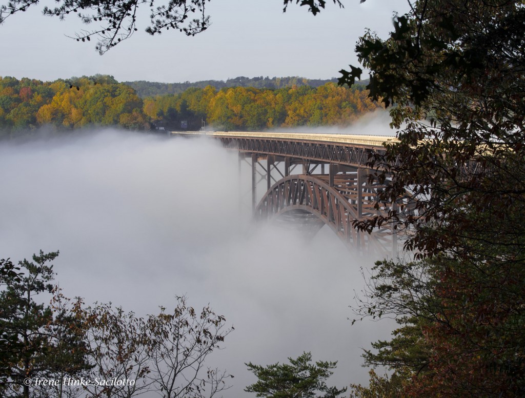
New River Gorge Bridge emerging from fog.
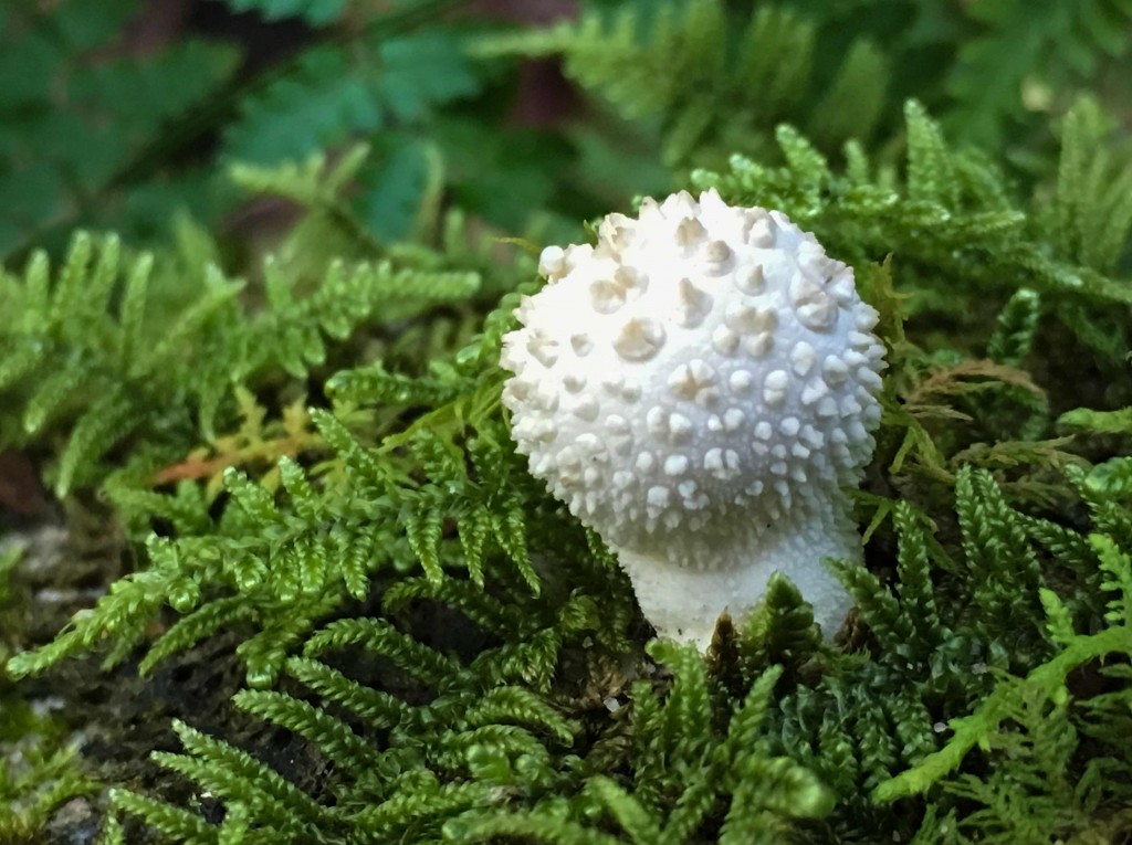
Cell phone shot of a mushroom along the trail to the canyon rim.
Babcock State Park and Glade Creek Grist Mill
The park is approximately an hour drive from Beckley, WV on back roads. I typically time my travel to arrive shortly after sunrise. This year mill’s water wheel was not turning due to damage caused by a severe flood in June. It is more likely to be operating in the spring when there is more water flowing in the adjacent creek. As with most of the locations visited this fall, the color of the surrounding trees was not intense, However the mill with the falls below still presents a number of interesting photo opportunities from both sides of the creek. Soft light is best at this location since on a sunny day as the sun moves higher in the sky, the contrast between the trees surrounding the mill and waterfalls intensifies. During this visit, I looked for subjects other than the mill to photograph, such as softly lit sections of the creek and colorful reflections in the water.

Glade Creek Grist Mill.
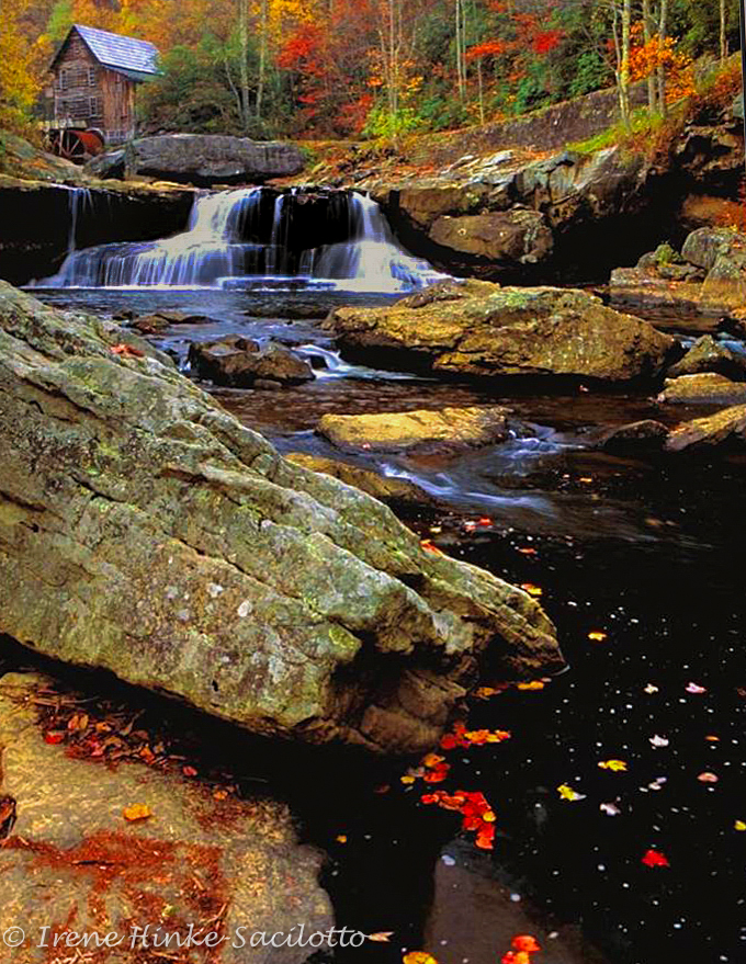
Glade Creek Grist Mill. Photo taken a number of years ago with better fall color.
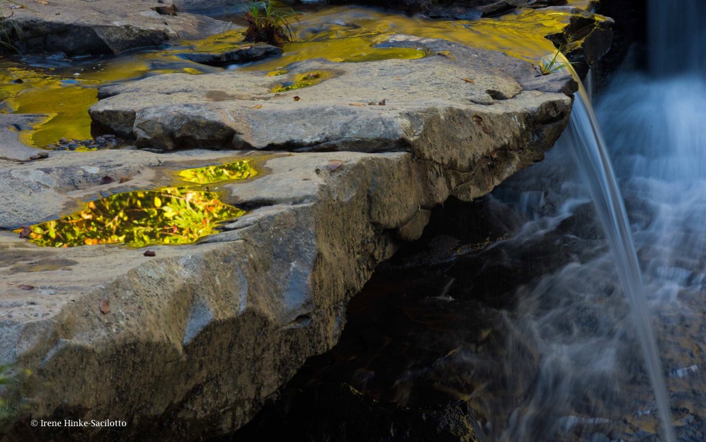
Reflections in puddles from surrounding trees. Falls at Glade Creek Grist Mill, Babcock State Park.
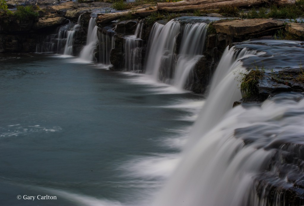
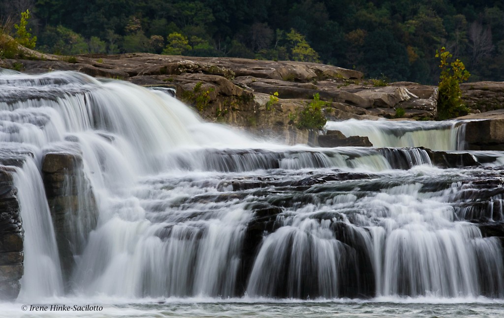
Sandstone Falls
Sandstone falls is the largest waterfall on the New River. Located at a wide point in the river where it is divided by a series of islands, the river drops 10 to 25 feet. A boardwalk with overlooks span the waterways and offer a number of views of cascades and main falls. The first overlook is my favorite, where there is a series of small falls fanning out in a horseshoe shape. There are places to photograph both from the boardwalk and river bank. Access to the higher upper falls is not always possible dependent on the water level.
To reach this section of the National Park, go to the small historic town of Hinton where you cross the New River and travel parallel to its path until you reach the park. (Approximately a one-hour drive from Beckley.) A neutral density filter will enable you to slow shutter speeds for an artistic presentation of the water’s flow. These filters are neutral gray and reduce the amount of light entering the lens. Some are variable in strength and therefore are more versatile. Remove your UV filter before mounting these or a polarizer on your lens Besides extra layers of glass that can soften your image and contribute to flare, when using a wide-angle lens, vignetting of the image can occur (darkening in the corners of the frame). Each time I have visited the park, photographic opportunities differ. As I was leaving the area this time and heading back to Hinton, I noticed the backlit spray of water from the main falls and foreground trees and took the photo below.
Intrigued by the backlit spray from sandstone falls and the foreground trees, I could not resist taking this photo.
The above photo was taken by one of my 2016 workshop participants, Gary Carlton. He used a variable neutral density filter to for the first time to blur the movement of the water. Pleased with the results, he submitted this image during the critique portion of the program.
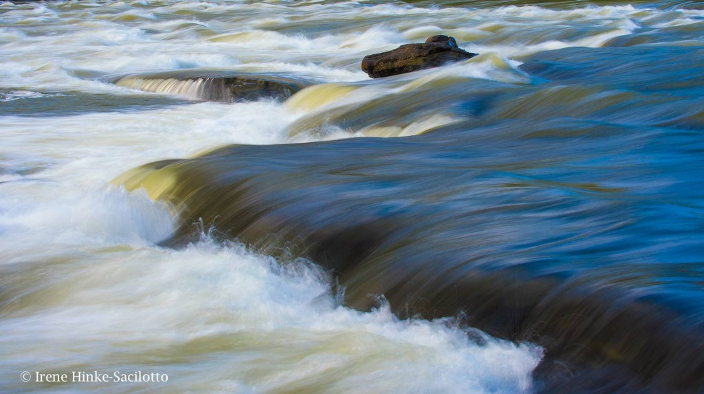
New River downstream from the main falls photographed with a slow shutter speed.
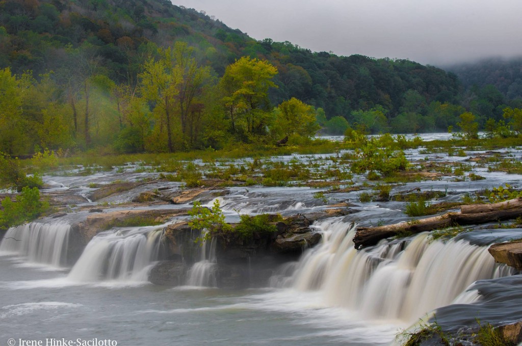
Foggy morning at Sandstone Falls.
Hawks Nest State Park
Hawks Nest State Park offers views of the New River from the side of the river opposite from the Canyon Rim visitor’s center. From Hawks Nest Lodge and overlooks from further down Route 60, there are interesting views of the river and surrounding mountains from a high vantage point. Also there is an aerial tramway to transport you from the lodge to the river below. When you reach the bottom jump off point, you can cross a small bridge and following an easy trail upstream to Turkey Creek Falls. Along the way you can capture photos of the trees gracefully overhanging the river, mushrooms, and wildflowers. Just before the Hawks Nest Dam, you reach a small bridge crossing the creek at the base of the falls. From the bridge and rocks below the falls, you have a good vantage point for photos. The best images of the falls have been taken in the spring when the flow of water is greater. During my visit this October, the flow was minimal.

Shot with the cell phone below Hawks Nest on the trail to Turkey Creek Falls. I used it to show workshop participants photo possibilities along the path to the falls.
Cathedral Falls
If you continue driving down Route 60 from Hawks Nest State Park, just before the town of Gauley Bridge, you will see Cathedral Falls on the right side of the road. Best photographed with late afternoon light. When the sun is high in the sky, there is too much contrast from the upper part of the falls to the base for a good exposure. I recommend using a telephoto lens to isolate portions of the falls, a 80 – 400 mm or 70 – 200 mm zoom lens. On the day of this year’s photo workshop, I spotted a rainbow reflecting in a portion of the falls. It would appear and disappear depending on where one was standing and only lasted for a brief period of time. Several workshop participants got great shots of the phenomena. During my scouting trip, the sky was slightly overcast and the rainbow was not present. But I still was able to capture the etherial beauty of the falls by isolating a section and using a slow shutter speed. Note: Typically I do not photograph with workshop participants during a weekend program, preferring to direct all my attention to helping them achieve the best results possible.
Cathedral Falls in soft light. The most beautiful portion of the falls captured with a telephoto lens.
Kanawha Falls
A short distance down Route 60 from Cathedral Falls is the small town of Gauley Bridge which provides access to the river for photos of reflections in the flowing water and of geese along its bank. Just southeast of Gualey Bridge is Glen Ferris where Gualey River and New River converge. Here you will find Kanawha Falls adjacent to a hydroelectric station. From a trail used by fishermen parallel to the main road, you can isolate a portion of the falls with a telephoto lens and exclude any evidence of the power plant. As an alternative, you can photograph the aging brick power station for a graphic image.
Kanawha Falls photographed with telephoto to isolate falls from its surroundings
Town of Thurmond
The historic town of Thurmond was once an active railroad town like many located along the New River. It can be reached off of Rt 19 at Glen Jean Exit north of Beckley. A narrow winding road leads to the town following a stream that cascades down the mountain. On the way down, there is a pull-off that provides relatively easy access to photograph one of the larger cascades.
At the base of the mountain, you reach the historic town of Thurmond by crossing an old narrow railroad bridge that spans the river. Ahead you will see a parking lot and railway station renovated by the National Park Service and serving as a Visitors Center. What makes this location special is that railroad tracks run through the center of town. Today only a few buildings remain from the past. However with a wide-angle lens, the train tracks create great lines leading into the frame. If you are there at the right time, you may be able to photograph a train as it approaches. Watch the signals above the tracks for an indication that one is on its way.
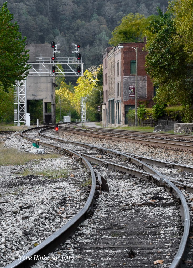
Railroad tracks at Thurmond.
Cascade on way to Thurmond.
Grandview, part of the New River Gorge National River, NP
Grandview lies within the National Park and provides views of the horse-snapped section of the river from 1400 feet above. In the early morning interesting shots can be obtained as the fog slowly lifts from the canyon floor revealing the river below. A trail follows the rim with a few small overlooks which are partially blocked by vegetation. Another overlook farther along the canyon wall is Turkey Spur. Steps lead to viewing platforms, but this year the upper level was closed due to fire damage. In May and June, I understand the area is quite beautiful with blooming rhododendron along the trails. This year there was little fall color but I did take an abstract photo of the forest by zooming my lens during a slow exposure. As I exited the park, I grabbed this photo of a white-tail deer.

Deer photographed just outside of Grandview.

Fall color at Grandview captured by zooming my 70-200 mm lens with my camera set on a slow shutter speed.
Fayetteville Station Road
The 100 year-old Fayetteville Station Road once regularly traveled before the modern New River Gorge Bridge was built in 1977. Access to the road is off of Rt 19 by turning right on Lansing-Edmond Road, near the Canyon Rim Visitors Center. Once on this narrow road, turn right at the sign “Fayette Station Road” and immediately take the left fork. This road is a very narrow with hairpin curves and sections that are only open to one-way traffic. It passes under the current bridge twice, offering unique views of the steel structure. Also it provides access to the banks of the New River, several small waterfalls, and Kaymoor trail which passes a historic coalmine site. The road is worth the drive but is closed to traffic during Bridge Day weekend when the New River Bridge is closed to vehicles an open to pedestrian traffic and BASE jumpers.

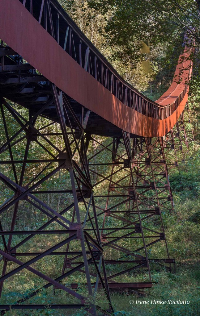
New River Gorge Bridge’s steel structure photographed underneath on Fayetteville Station Road.

By selecting sections of the bridge’s iron work, you can create interesting abstract photos.
Nuttallburg Town
Nuttallburg was one of a number of bustling coal mining towns along the New River. The abandon townsite for years was concealed under the cover of trees and vines. It was recently restored by the park service and can be reached from Lansing-Edmond Rd by turning right in the community of Winona onto Keeneys Creek Road. This very narrow road descends into the gorge to a parking area. From here, trails lead to the foundations of buildings and remains of coke ovens that converted the coal into fuel. The most interesting aspect of the site is the coal tipple and conveyor that transported the coal from the mine up the mountainside down to the processing area and railroad below. On a bright sunny day, the scene is difficult to photograph without using HDR technology. The contrasty photo below was taken this fall at mid-day while scouting locations to determine which to include in my upcoming workshop.
Coal conveyor at Nuttallburg Town. The amount of contrast in the scene was high resulting in distracting deep shadows and burnt-out highlights.. It would be best to photograph this scene when the light is softer.
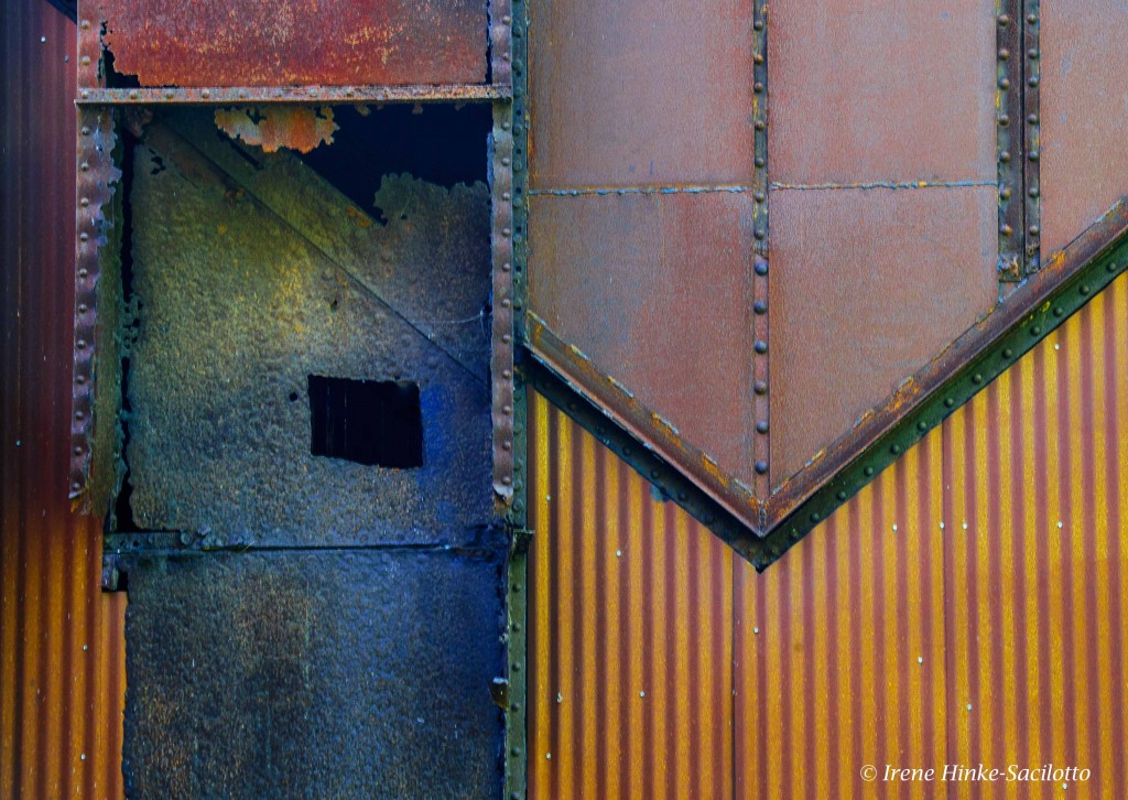
Side of the old tipple in Nuttallburg Town I was attracted to the colors, shapes, textures, and lines displayed by the wall and took this photo of the abstract design. The side of the building was shaded, perfect for this photo.

by Osprey Photo Workshops & Tours | Nov 6, 2016 | Autumn photography, Fall photography, Nature Photography, North Dakota, Photo Tour, Photo Tours, Photo Workshops, South Dakota, Wildlife, Wildlife Photography

NORTH AND SOUTH DAKOTA BADLANDS, Trip Report, September 2016.
While scouting locations with Sandy Zelasko and preparing for our spring workshop, we visited both the Badlands in North Dakota (Theodore Roosevelt NP) and the Badlands and Black Hills in South Dakota.
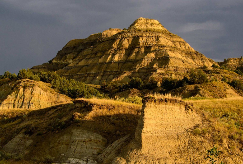
Badlands in North Dakota, Theodore Roosevelt NP.
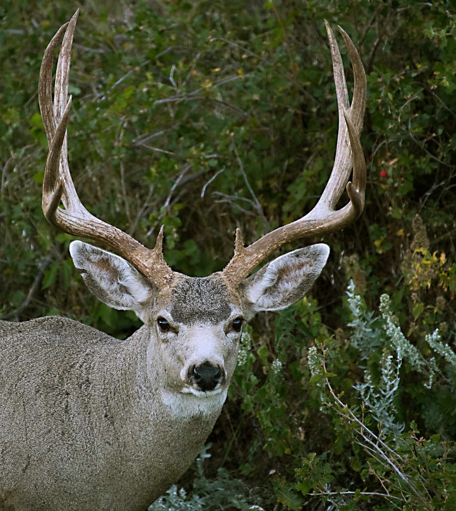
The Badlands of THEODORE ROOSEVELT National Park (NP) in North Dakota were impressive but not as colorful as those in South Dakota. However some eroded formations were unique including spheres and other oddly shaped rocks balanced on top of ridges or embedded in canyon walls. My favorite subjects were the wild horses, which we encountered in several locations. In North Dakota, the wildlife was not as visible or easy to photograph as in South Dakota Badlands where we found bighorn sheep, pronghorn antelope, mule deer, prairie dogs, buffalo, turkey, grouse, and in the past, badger. From our modest but comfortable motel (Cowboy Inn) in the town of Belfield, ND, we were approximately a 20-minute drive from the southern entrance to the park and an hour from the northern segment. Both areas are worth visiting. However after comparing our experiences in both North Dakota and South Dakota, we decided that the best photo opportunities with a mix of wildlife and landscape photography was in the South Dakota Badlands where we will offer our next photo workshop in early June 2017.
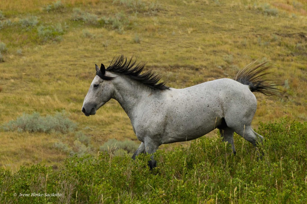
Wild horse

Deer a field in North Dakota
North Dakota Badlands with slanted rock.

Buffalo at sunset.
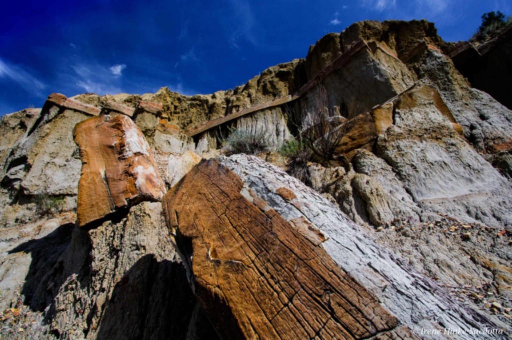
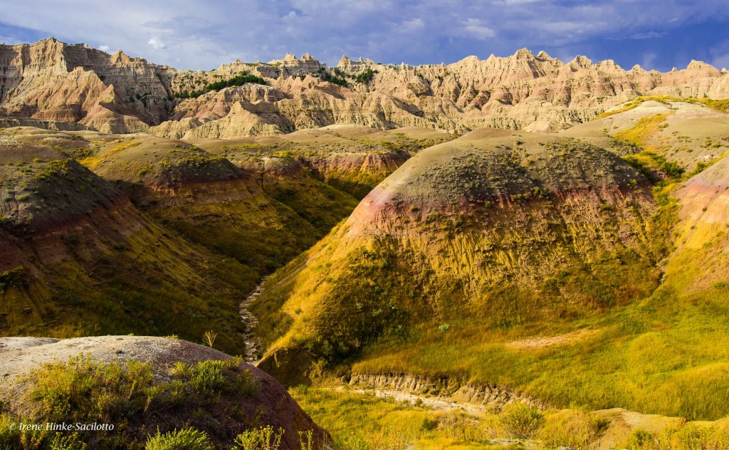
A paved road loops through the 24,000 acre Badlands NP in South Dakota with scenic overlooks and traveling between the sharply eroded buttes, pinnacles, pedestals, and spires and undisturbed mixed grass prairie that characterizes the park. The badlands were formed from alternating layers of hard and soft rocks and soil. Easily eroded materials such as clay or mud-stone is topped by more resistant materials, such as sandstone, with the harder horizontal layer protecting the soft deposits. There are a number of hiking trails to provide a closer look at the unique geology of the region. North, Door and Window trails near the North East entrance to the park meander amongst the formations, for an up-close and personal look at the rocks layers.
Yellow Mounds
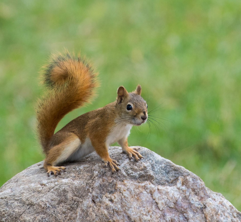
Red Squirrel
It s hard to pick a favorite location for photography within the park since there were so many sites to choose from. I loved the sulfur mounds and eroded formations near Dillon Pass and Conata Basin but was equally fascinated by the alternating tan and rusty bands of color from oxidized iron near Saddle Pass Trail. Southern views from Sage Creek Rim Road also offered great opportunities for landscape photography with deep ravines and colorful mounds eroded by wind and rain. Along the
gravel road is a good place to spot wildlife in and about Roberts Prairie Dog town. Buffalo, pronghorn, and bighorn sheep graze on the grasses while coyotes stalk unsuspecting prey. It was here I photographed a badger at close range during my last visit. Actually the best place this year for prairie dog shots was along a less traveled dirt side road running north as you head east past Contata Road and Dillon Pass. With little disturbance from traffic, the prairie dogs were more cooperative and allowed us to shoot belly down on the ground. More remarkable, along the same road, a coyote slowly walked towards our car and crossed the road in front us into the grassland paying little attention to the sound of our cameras firing off a burst of shots.

Bighorn Sheep
Sheep Mountain Table in the Southern Stronghold area of the park is worth a visit if you have a car with high clearance able to climb the steep dirt road that leads to the top of the mesa. It’s a peaceful place with few visitors where you can enjoy views in all directions from the high vantage point. On the Western edge of the Badlands on the way to the mesa from Sage Creek Rim Road, Scenic is a nearly abandoned town off the main highway that offers you a glimpse in the past with unique photo opportunities. Here you can photograph your friends behind bars in a historic jail or in front of the once lively Longhorn Saloon where steer skulls line the roof of the building. If you look hard at the sign on the face of the building, you will notice a somewhat disturbing message indicating who was welcome. If you look hard, the first word “NO” is painted over.
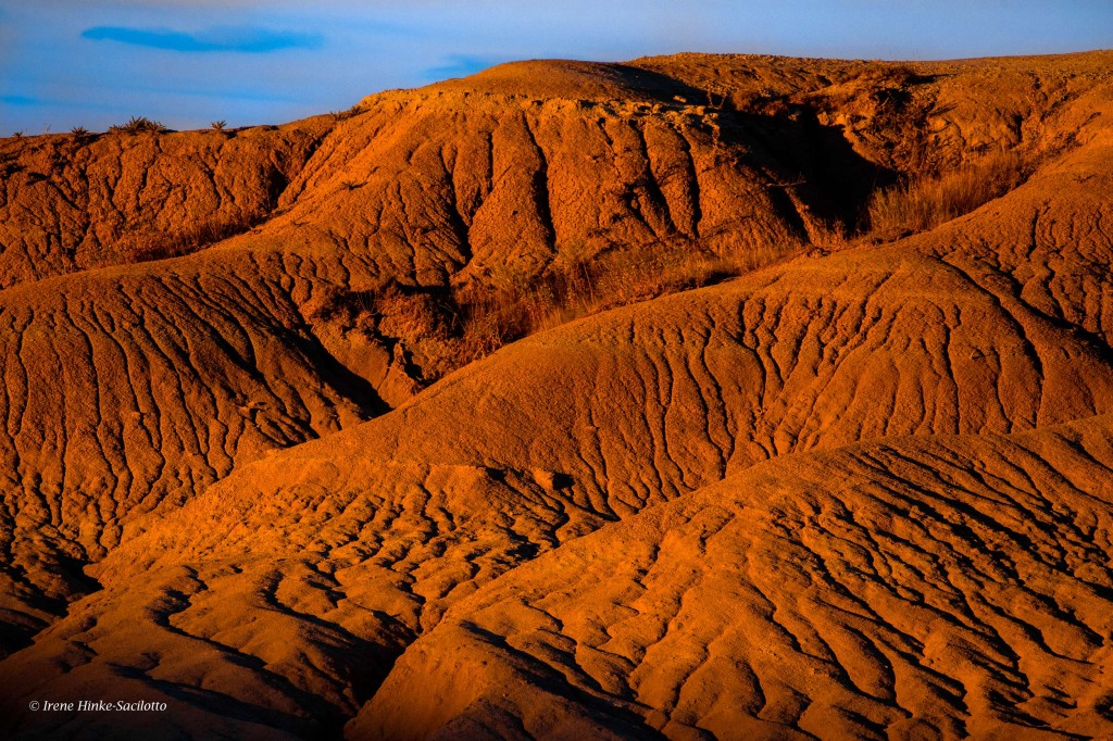
Eroded mounds at Sunset
GIGANTIC FIELDS OF SUNFLOWERS. On the first leg of the trip, Sandy and I explored the back roads from Rapid City to Belfield, ND, where we stayed while exploring the area. From there headed south to Wall and the Badlands of South Dakota. Along route 73 south of Lemmon and elsewhere, we discovered huge fields of sunflowers, much larger than any I have seen in Maryland. Although some flowers were past their prime, we stopped to take photos of several fields in prime condition with macro, telephoto, and wide-angle lenses. Surprised at the number and size of the fields, I checked the Internet to find that this area is one of the highest producers of sunflowers in the U.S. The seeds are used in the production of sunflower oil as well as for consumption by humans and birds.
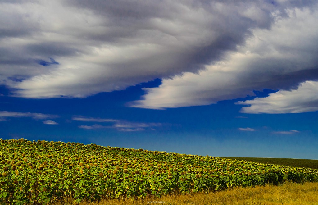
Sunflower field

Marmot
It was 13 September, not a holiday weekend, when we entered the southern gate of CUSTER STATE PARK and encountered bumper-to-bumper traffic on the loop road. There were several tour vehicles with park visitors and accompanied by guitar-playing singers. Needless to say, this was not the environment I had remembered from past visits. Instead of the “wild” burrows grazing on the hillsides and dusting in areas devoid of grass, they gathered on the road, sticking their heads into car windows and begging for food. Also there were more fences than I remember from a previous trip limiting photography in certain areas, but we were told the fences were there to protect sensitive habitat from overgrazing. As we moved further along the loop road the situation improved. We did encounter a large herd of buffalo, lots of bluebirds, a few mule deer, bighorn sheep, and pronghorn. Our favorite areas were along the gravel roads that branched off the main route. Here there was little traffic and the rolling hills were beautiful particularly on the route that led into the backcountry of Wind Cave NP. We encountered buffalo, herds of pronghorn, and the possibility of seeing elk. We found photographing in Wind Cave National Park was more productive with pronghorn on hillsides, energetic red squirrels retrieving and storing pinecones for the winter, wild turkey, and mule deer adjacent to the road.
Needles Highway in the Black Hills not far from the town of Custer includes 14 miles of sharp turns, low tunnels and impressive granite spires. It is a good spot to look for mountain goats, which are known to frequent the high country near Cathedral Spires and Needles Eye Tunnel. They have even been photographed inside the tunnel licking minerals from the rock walls. With little time remaining on our scouting trip, we drove the highway one morning in search of goats but when a heavy fog engulfed the Needles, we could hardly see the car in front of us let alone spot their white coats. The highlight of the drive was witnessing a full sized tour bus carefully position itself and pass unscathed through Needles Eye Tunnel while the extended side mirror of a pick-up truck that entered before the bus scrapped the inside of the wall.

Tour bus
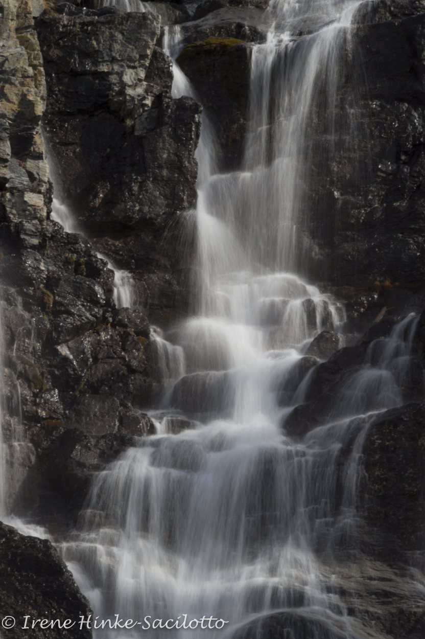
We made a short side trip to Spearfish Canyon on 16 September. We were a bit early for fall color in the canyon, which I had enjoyed on a previous trip. The waterfalls were impressive particularly Roughlock Falls. Bridal Veil falls had little flow and would have been more impressive if it was surrounded by fall color or snow covered trees. Spearfish Falls is near the Southern entrance to the canyon and is photographed best in soft light in the early morning.
NOTE: You are likely to encounter the best leaf color in the South Dakota Badlands and Black Hills the last two weeks of September.
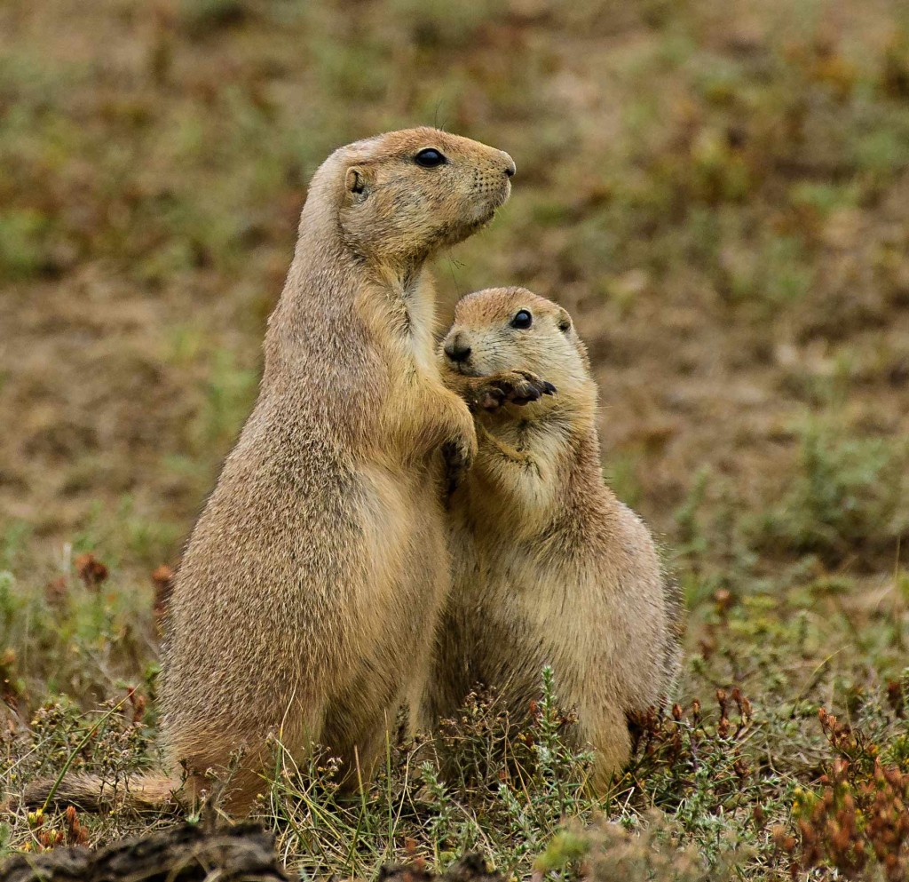
Praire Dog biting paw.

by Osprey Photo Workshops & Tours | Dec 17, 2015 | Autumn photography, Canadian Rockies, Digital Photography, Fall photography, Nature Photography, Photo Tour, Photo Tours, West Virginia, Wildlife Photography
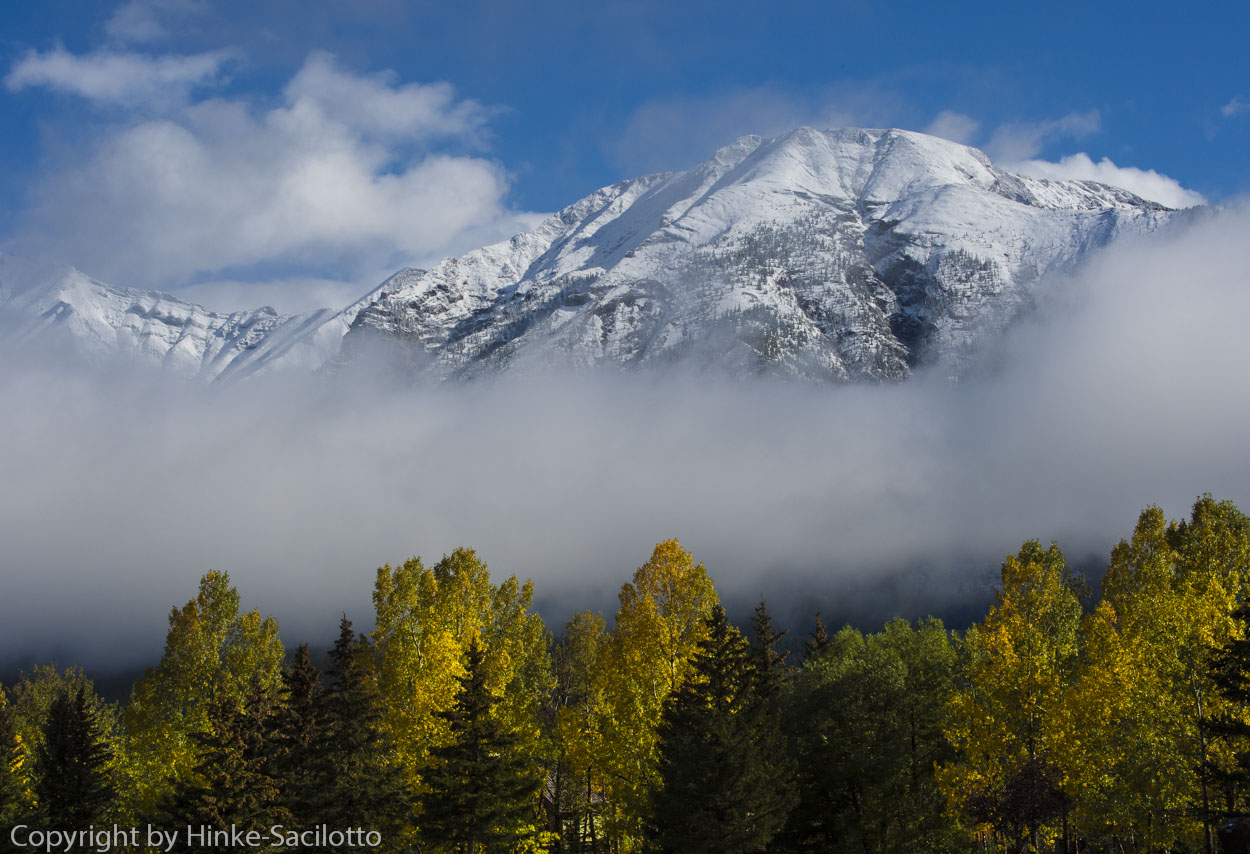
Two of my favorite locations for autumn photography are the mountains of West Virginia and the Canadian Rockies.

Aspen on hillside, Canadian Rockies
With the arrival of fall, to the delight of photographers, leaf color changes, birds migrate, and animals move from the high country to lower elevations. But also rain and overcast skies often accompany the seasonal change as temperatures fluctuate and the weather becomes less stable. Such conditions can render images dull and flat, but can also be an asset.
Rain – the Sliver Lining
In the Canadian Rockies this September, we had 2 days of continuous hard rain, so much that rock slides blocked the main highway. We just took the time to relax, read, and work on images. Although being driven inside by the rain was disappointing, the following morning was spectacular with beautiful fresh snow on the mountain tops.

Snow Peaks, Canadian Rockies
Rain can be a both a blessing and a curse. With rain, the grass becomes greener, rainbows appear, water droplets adorn leaves and spider webs, pools of rainwater reflect the colors around them, and waterfalls and cascades flow more swiftly. The color of vegetation becomes more saturated. By using a polarizing filter to remove shine on surfaces, you can make colors even more intense.
Tangle Falls after rainfall.
Ok, so the next image is not related to fall photography but it makes the point that rain can be a good thing. My photos that I shot in Costa Rica of hummingbirds in the rain, were some of my favorite from that trip. (A cheap kids poncho or large plastic bag will keep your gear dry in case of an unexpected downpour.)

Fiery-throated Hummingbird in the rain, Costa Rica
Fog & Overcast Skies
Overcast skies, low cloud banks, and fog generated by temperature changes in the fall can present photographers with unique photo opportunities. When I rise in the morning, I let the light direct my activities. On a foggy morning, I will head to a nearby lake, pond, or low area where the fog creeps along the ground and slowly rises with the heat of day to reveal interesting ghost-like silhouettes of trees, bushes, and mountains ranges. If in Shenandoah National Park, I am likely to go to a high point to photograph the fog hanging in the valleys between the mountains. (Note: Be careful when exposing foggy scenes. Depending on your camera, if your light meter is reading off of the fog layer, then it will adjust the exposure to render the fog mid-tone gray. This will often result in an underexposed photo. Add more exposure to compensate).

Snow covered peaks near Canmore, Canadian Rockies

Morning fog over river, Jasper, Canadian Rockies
Blackwater Falls State Park, Fog over Pendleton Lake.at dawn.
If instead of fog, I wake to a sky that is lightly overcast, I will head to a location where the soft light complements the scene, e.g. to a waterfalls, cascade, stand of trees, woodland trails, flowing streams, delicately colored wildflower, etc. On a bright sunny day, photographs of these subjects will often be disappointing with distracting backgrounds, hot spots, and deep shadows that hide important details. (If the sunlight becomes to bright for your subject, you can sometimes get acceptable results by waiting until the light is diffused by a passing cloud.)

Linde Point, Blackwater Falls State Park, view down Blackwater Canyon. Soft light reveals details.
The Wonders of Backlighting
Backlighting and side lighting bring out the vibrant color of autumn leaves. By using a polarizing filter you can intensify the effect by removing glare from the surface of vegetation. Even towards mid-day, polarizers can sometimes help you achieve satisfactory results. Take note that flare can be a problem when pointing the camera towards the sun. Flare appears as unwanted bright spots across the image or a bright wash over the photo. Flare spots are created by the sunlight reflecting off of glass surfaces within the camera lens or filter. How can you reduce flare? Your lens shade can help but you may need more assistance. You can shadow the lens with a jacket, hat, card, umbrella, or person’s shadow. You can also stand in the shade of a tree or building. Sometimes you can reduce flare by aiming your lens such that the sun is blocked by an object such as behind a cloud or tree limb.

Pond at Canaan Valley State Park. Fall color reflecting in a pond. (For reflections in ponds and lakes, you may capture better color in the water from the surroundings trees by moving to a higher vantage point where more of the water’s surface is visible.)

Backlit fern

Backlit Tree, Canaan Valley

Dolly Sods. Leaves from blue berry bushes turn red in the fall and glow when struck by the late afternoon sun.
Isolation and macro landscapes
Instead of using your wide-angle lens for all landscape photos, consider isolating portion of the scene using a telephoto or macro lens. (Be careful when using wide-angle lenses for landscapes. They alter perspective and shrink the size of items in the background; thereby, lessening the impact of a photo. The mountains you emotionally reacted to are reduced to bumps on the horizon.)
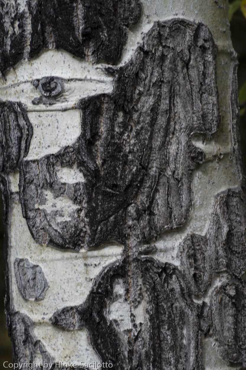
For any photo, identify what attracted you to the scene. Then chose your lens , angle of view, lighting, etc. to emphasize what initially impressed you. Concentrate on the key elements and simplify the image, eliminating the non-essential components. Instead of capturing a broad landscapes all the time, look for patterns and portions of the scene that have high visual impact. These are what I call macro landscape. Little things such as bubbles in a stream, water droplets on a fallen leaf, lichen covered rocks, distinctive patterns on tree bark, colorful reflections in a pond, the flow of water across a rock, etc. can be perfect photo subjects.

Bubbles in stream

Fallen leaves floating in pond, fall color, Canaan Valley

Iceland cascade.

Bark Patterns
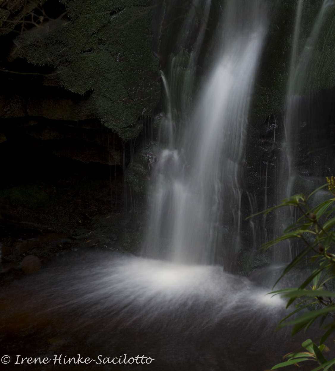
Slow Shutter Speeds
For streams and waterfalls, its fun to experiment using low ISOs, small apertures, and neutral density filters, achieving slow shutter speeds to blur the motion of the water for an artistic effect. With flowing streams, slow shutter speeds can add sense of motion which can be sometimes enhanced by swirling patterns of colorful leaves, bubbles, or foam. There is no way to perfectly predict what the final results are going to be, so take a number of shots with different settings. Use your camera’s playback mode to judge results.

Slow shutter speed. Photo of cascade. Canadian Rockies.

Swirling water in a stream.

Roadside cascade, Canadian Rockies. Slow shutter speed to show action. Soft light to avoid hot spots.
Location, Location, Location
If the leaf color is not good in one area, don’t give up. It might be spectacular a short distance down the road. Autumn colors vary with temperature, rainfall, and altitude. The arrival of peak color in any one location varies from year to year.

Fall color reflected in a stream, West Virginia, Near Elkins, WV. Spotted the possibilities as I was crossing the bridge where I took this photo.

by Osprey Photo Workshops & Tours | Oct 21, 2015 | Autumn photography, Fall photography, Nature Photography, Photo Tour, Photo Tours, West Virginia

Dolly Sods
West Virginia Fall PhotoTour (Trip Report)
Blackwater Falls State Park is situated in the West Virginia mountains near the town of Davis and is approximately a 5 hour drive from my home on the East side of Baltimore. Canaan Valley National Wildlife Refuge and Canaan Valley State Park are only a short distance from Blackwater. They all lie within Canaan Valley, a 13 mile long high valley, nestled among the higher ranges of the Allegheny Mountains. The average valley floor elevation is 3,200 feet (980 m) above sea level which accounts for its cooler temperatures and early arrival of fall. Within the valley are extensive wetlands and the headwaters of the Blackwater River which spills out of the valley as Blackwater Falls. Highly photogenic, its amber-colored water plunges down 62 feet before cascading through an eight-mile long gorge (Blackwater Canyon).

Blackwater Falls
This part of West Virginia is a favorite destination of mine during the first two weeks of October when the hillsides are ablaze with the colors of autumn. This year the colors were less then prime due to wet weather and warmer temperatures but still beautiful. Views from the overlooks at Blackwater Falls State Park such as Pendleton, Linde, and lodge provided ample photo opportunities. Canaan Valley State Park offered more opportunities to capture fall color as the sun back-lit the leaves of aspen, maple, oak, and fern. In ponds and along the Blackwater River, the colors from the surrounding vegetation reflected in their surface. For the first time in a long while, I took the Canaan Valley ski lift to a ridge opposite the park. (The lift does not operate all year so check the schedule if you are interested). Once I step off the lift, it was a bit of a hike to reach an open area with a clear view of the valley, but the trek is worth it. As I climbed towards rocks of Bald Knob, along side the trail I encountered a large group of vibrantly colored red-leaved blue berry bushes which begged to be photographed. From here, I continued to follow the trail upward until I finally reached the rocky overlook with a panoramic view of Canaan Valley. After sitting down for a few minutes and enjoying the view, I began to photograph the valley below using the large bolders as foreground. (You can either return to the parking area the way you came using the lift or follow a steep, leaf covered trail to the bottom. The later can be a bit challenging but I made it down despite being a little sore the next day).

View or Canaan Valley.

Way to Elkins, WV
While in the area, it is worth visiting Dolly Sods, a high rocky plateau. Its 10,215 acres, are part of the Monongahela National Forest and Allegheny mountain range. As a result of logging, fires, and harsh winters, the plant life is unique and more similar to that found much farther north with one-sided trees, sphagnum bogs, and low growing bushes. There are 3 main access roads to the road that runs the length of the ridge of Dolly Sods. All are gravel and can be a bit challenging for cars with low clearance. There are a number of overlooks of the Allegheny mountain range once you reach the top. My favorite area is the end near the end of the road in a section known as Bear Rocks. Here there are few trees, large lichen covered boulders, and fields of blueberry and cranberry bushes with leaves that turn red in the fall. Late in the afternoon, these leaves glow when backlit by the setting sun. (See under tips, notes for avoiding flare in your photo). This year the leaves were more brown than previously but there were still some areas where the color was nearly prime. It had rained the day before I arrived and puddles had formed on the trails. The water reflected the blue of the sky and the colors from the surrounding vegetation offering some unique opportunities for photography.

Dolly Sods

Dolly Sods
No mater when you visit, these West Virginia treasures offer the photographer plenty to photograph. There are more possibilities in Southern West Virginia, where I have done workshops in the past–the New River Gorge, Sandstone Falls, Grand View, Babcock Mill, Pipestem State Park, Hawks Nest, and other locations offer photographers great photo opportunities in the fall. Fall comes a bit later in these locations – late October. No matter where you go, think of photographing more that the grand vistas and consider simple things like bubbles in a stream, water droplets on the grass, a caterpillar, a backlit fern, or a deer drinking from a pool of water. The possibilities are endless for an autumn photo tour.


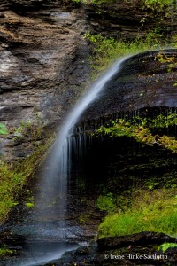
Elakala Falls near blackwater lodge
Robert Hitchman in his “Photograph America Newsletter” describes autumn photo opportunities in locations across the U.S. including Vermont, Connecticut, Michigan, New Hampshire, and more. wwww.photographamerica.com


